Treating an airborne infrared camera as a direct thermometer—or assuming a missing person always glows bright white against the terrain regardless of clothing, surface reflectivity, or solar hour—causes thermal drone search and rescue sorties to fail when crews fly past low-emissivity survivors or stall on false-positive rock clutter. An uncooled Longwave Infrared (LWIR, 7.5–13.5 µm) microbolometer does not read kinetic temperature (T_obj); it integrates total radiant exitance (M_total, in W/m²) across each pixel’s instantaneous field of view, summing self-emitted thermal radiation (ε × σ × T_obj⁴) with reflected background radiation ((1 − ε) × σ × T_refl⁴) while subject to diurnal contrast loss and pixel dilution. Whether a survivor is detected on the first pass depends on three coupled physical variables: surface emissivity (ε), diurnal solar loading (ΔT across time of day), and tactical sensor configuration (flir sar settings and white hot vs ironbow sar palette selection).
UAS Triple Challenge (uastriplechallenge.com) is an independent technical publication named after the domain once used by the 2021–2022 First Responder UAS Triple Challenge prize competition and is not affiliated with NIST, Kansas State University, Mississippi State University, Teledyne FLIR, or DJI.
In Longwave Infrared (7.5–13.5 µm) aerial thermography, total radiant exitance from an opaque surface (τ = 0, reflectivity ρ = 1 − ε) follows the Stefan-Boltzmann radiometric equation M_total = ε × σ × T_obj⁴ + (1 − ε) × σ × T_refl⁴. While bare human skin behaves as a near-ideal blackbody (ε = 0.98, +32 °C to +35 °C normothermic), an aluminized Mylar emergency space blanket (ε = 0.04–0.09, 91%–96% reflective) reflects the freezing zenith night sky (T_sky = -40 °C to -60 °C), causing a +30 °C hiker to register at an apparent temperature of -20 °C to -37 °C. Across the 24-hour diurnal cycle, midday solar irradiance (800–1,000 W/m²) heats granite boulders, bare soil, and deadfall timber to +40 °C to +60 °C (ΔT = -10 K to -25 K inverted clutter), while morning and evening thermal crossover windows (30–90 min post-sunrise and 30–90 min post-sunset, with 2–4 hr rock lag) collapse thermal contrast (ΔT -> 0 K)—making Pre-Dawn (02:00–06:00, ΔT = +12 K to +28 K) the optimal SAR window. Under Johnson’s criteria across a 0.50 m human target (GSD = (AGL × pixel_pitch) / focal_length), operators require 1.5–2.0 px (GSD <= 25–33 cm/px) for Detection, 6.0 px (<= 8.3 cm/px) for Recognition, and 12.0 px (<= 4.2 cm/px) for Identification, paired with High Gain mode (-20 °C to +150 °C), Sky-Exclusion AGC ROI (bottom 66%–80%), manual FFC shutter timing, and a two-stage palette doctrine (White Hot / Black Hot for wide-area scanning, Ironbow for hover confirmation).
| Radiometric or Operational Parameter | Governing Equation / Physical Standard | Optimal SAR Baseline Reference | Degraded or Failure-Mode Condition | Field Mitigation & Sensor Protocol |
|---|---|---|---|---|
Stefan-Boltzmann LWIR Exitance (M_total) |
M_total = ε × σ × T_obj⁴ + (1 − ε) × σ × T_refl⁴ (7.5–13.5 µm, ρ = 1 − ε) |
Exposed skin ε = 0.98 (+32–35 °C, ~493 W/m²); snow/nadir water ε = 0.96–0.98 |
Aluminized Mylar blanket (ε = 0.05, ρ = 0.95) reflects -45 °C clear sky → T_app = -20 °C to -37 °C; dry nylon shell (ε = 0.88) equilibrates within +1–3 °C of ambient air |
Brief visual observers to interrogate sharp geometric cold black spots (-15 °C to -40 °C) as well as warm hotspots; scan for 1–3 px of unhooded face/hands |
Diurnal Thermal Contrast (ΔT_app) |
ΔT_app = T_app_target − T_app_background; Crossover when ` |
ΔT_app | < 1.5 K` | Pre-Dawn (02:00–06:00): terrain 0–15 °C, target +26–34 °C → ΔT = +12 K to +28 K; Late Night (22:00–02:00): +10 K to +22 K |
Johnson’s DRI & Ground Sample Distance (GSD) |
GSD = (AGL × p_pixel) / f across d_crit = 0.50 m human width |
Detection (1.5–2.0 px): GSD <= 25–33 cm/pxRecognition ( 6.0 px): GSD <= 8.3 cm/pxIdentification ( 12.0 px): GSD <= 4.2 cm/px |
Wide 4.9 mm 640×512 lens at 120 m AGL gives GSD = 29.4 cm/px (1.7 px across 0.50 m), unable to separate a curled human from a warm rock or deer |
Fly 1280×1024 (H30T 24 mm: 6.0 cm/px at 120 m = 8.3 px Recognition), or descend / switch to narrow optical thermal focal length (<= 8.3 cm/px) to confirm targets |
| FLIR SAR Gain, AGC & FFC Settings | NETD_actual = NETD_f1.0 × (f/#)²; 14/16-bit raw mapped to 8-bit (256-step) display |
High Gain (-20 °C to +150 °C), NETD <= 20–50 mK; gimbal -45° to -90°; Sky-Exclusion ROI (bottom 66%–80%) |
Low Gain (0–500 °C) degrades contrast 3–4x; -50 °C horizon sky stretches AGC over 78 K (washing out ground); 0.5–1.0 s Auto-FFC freezes video for 5–10 m at 10 m/s |
Lock High Gain; pitch gimbal down to exclude sky or lock Manual Span (15–20 K window); trigger Manual FFC prior to entering each search leg |
Spot-Size Ratio (SSR) & Isotherms |
M_pixel = Σ (A_i / A_px) × M_i over GSD² pixel footprint |
Open upper-threshold isotherm set +3 °C to +5 °C above max background in cool night terrain |
Narrow +30 °C to +37 °C human-skin isotherm at 60–120 m AGL misses clothed/hypothermic victims whose 20 cm pixel averages 25% face (+33 °C) + 75% soil (+8 °C) = +14.7 °C |
Never rely on a +30–37 °C isotherm at search altitude; scan in unmasked White Hot / Black Hot and verify pixel fill before trusting spot-meter readings |
Palette Doctrine (White Hot vs Ironbow SAR) |
Luminance (M-pathway) edge speed vs Chromatic (P-pathway) ring separation |
Stage 1 Scan: White Hot (night/canopy) or Black Hot (day/snow/hot sand) |
Scanning wide grids in Ironbow or Rainbow creates chromatic false edges across rocks/trees and accelerates operator visual fatigue |
Enforce Two-Stage Palette Doctrine: White Hot / Black Hot for continuous grid scanning → switch to Ironbow only in stationary hover to confirm concentric body heat gradients |
LWIR radiometric physics: VOx microbolometers, emissivity (ε), and the Stefan-Boltzmann exitance equation
In classical search theory—as mapped in our pillar analysis on drone search and rescue under forest canopy and our geometric guide to search grid patterns and probability of detection—the probability of success (POS) inside a search sector is the product of containment probability (POC) and detection probability (POD):
POS = POC × POD and C = W / S
where coverage factor C equals effective sensor sweep width (W) divided by parallel track spacing (S). On paper, flight-planning software treats thermal sweep width W as a fixed geometric swath width derived from camera Field of View (FOV). In physical reality, an airborne thermal sensor detects a missing person only when the radiometric exitance contrast (ΔM) between the human target and the surrounding background exceeds the detector’s noise floor (NETD) and Automatic Gain Control (AGC) quantization step across at least 1.5 to 2.0 adjacent pixels.
Why search-and-rescue drones operate in the 7.5–13.5 µm LWIR band
Unlike electro-optical (EO, 0.4–0.9 µm visible and near-infrared) CMOS cameras that require reflected sunlight or artificial illumination, public-safety thermal cameras operate in the Longwave Infrared (LWIR, 7.5–13.5 µm or 8–14 µm) atmospheric transmission window. Two physical laws dictate this band selection for search and rescue:
- Wien’s Displacement Law Peak (
λ_max = b / T): Every object at absolute temperatureT(in Kelvin, K = °C + 273.15) emits a continuous Planckian spectrum whose peak wavelengthλ_maxis inversely proportional to temperature (Wien's constant b = 2,897.77 µm·K):λ_max = 2,897.77 / T(µm)- For normothermic exposed human skin at
T_skin = +33.0 °C = 306.15 K:λ_max = 2,897.77 / 306.15 = 9.47 µm - For temperate forest, rock, and soil backgrounds at
0 °C to +25 °C(273.15 K to 298.15 K):λ_max = 9.72 µm to 10.61 µmThe7.5–13.5 µmLWIR band sits squarely on the maximum radiant emission peak of both human subjects and terrestrial backgrounds, day or night.
- For normothermic exposed human skin at
- Atmospheric Window Transmittance (
τ_atm) vs Water Droplet Scattering: Between5.0 µm and 7.5 µm, atmospheric water vapor (H2O) strongly absorbs infrared radiation; above14 µm, carbon dioxide (CO2) closes the window. The7.5–13.5 µmband provides high clear-air transmission (τ_atm ≈ 0.85 to 0.96over50–150 mslant ranges). Furthermore, because10 µmLWIR wavelengths are roughly20xlonger than0.5 µmvisible light, LWIR penetrates fine smoke aerosols (particle diameter d << 10 µm, Rayleigh regime) far better than visible cameras—though heavy fog, cloud mist, and falling rain (droplet diameters 10–1,000+ µm, Mie and geometric scattering regimes) strongly absorb and scatter8–14 µmradiation, rapidly collapsing thermal range.
Uncooled Vanadium Oxide (VOx) microbolometer architecture and NETD sensitivity
Modern multirotor SAR gimbals use uncooled Vanadium Oxide (VOx) resistive microbolometer focal plane arrays (FPAs) rather than cryogenically cooled Indium Antimonide (InSb, 3–5 µm MWIR) sensors, avoiding the weight, 30–60 W cooler power draw, and 5–8 minute cool-down delay of Stirling engines. Each pixel on a VOx FPA is a microscopic, thermally isolated bridge coated with a thin film of vanadium oxide whose electrical resistance changes sharply with temperature (Temperature Coefficient of Resistance TCR ≈ -2%/K to -3%/K). Incident 7.5–13.5 µm photons pass through a Germanium (Ge) or Chalcogenide lens (opaque to visible light, refractive index n ≈ 4.0 in LWIR with anti-reflective Diamond-Like Carbon coating), heat the suspended micro-bridge, and generate a 14-bit (16,384 count) or 16-bit (65,536 count) digital readout.
The fundamental sensitivity metric of a VOx sensor is Noise Equivalent Temperature Difference (NETD or NEDT, measured in milliKelvin, mK)—the target temperature difference required to produce a signal-to-noise ratio of 1.0 (SNR = 1:1) against temporal readout noise at a standard f/1.0 lens aperture. Remember that effective system NETD degrades with the square of the lens f-number (f/# = f / D_aperture):
NETD_system = NETD_f1.0 × (f/#)²
Moving from a fast f/1.0 lens to a slower f/1.4 lens doubles the noise floor (1.4² = 1.96x), which is why dedicated SAR thermal cores pair 12 µm or 8 µm VOx detectors with ultra-fast f/0.95 to f/1.0 optics.
| Thermal Sensor Core / Integrated SAR Gimbal | Detector Material & Spectral Band | Array Resolution & Pixel Pitch (p_pixel) |
Lens Focal Length (f), Aperture & Field of View |
Thermal Sensitivity (NETD) |
Frame Rate & Radiometric Output |
|---|---|---|---|---|---|
Teledyne FLIR Boson+ (640) (OEM Core) |
Uncooled VOx Microbolometer (7.5–13.5 µm) |
640 × 512 (0.33 MP, 12 µm pitch) |
Modular lenses: 4.9 mm (95° HFOV), 9.1 mm (50°), 14 mm (32°), 18 mm (24°), 24 mm (18°), 36–73 mm (12°–6°) |
<= 20 mK (0.020 °C) |
60 Hz / 30 Hz; 14-bit digital CMOS / USB UVC |
Teledyne FLIR Boson SX8 (1280) (OEM SXGA Core) |
Uncooled VOx Microbolometer (7.5–13.5 µm) |
1280 × 1024 (1.31 MP SXGA, 8 µm pitch) |
SXGA LWIR optics (12° to 95° HFOV, e.g., 24 mm = 24.1° HFOV) |
< 25 mK (std) / < 35 mK |
60 Hz; 14-bit raw radiometric telemetry |
Teledyne FLIR Vue TZ20-R (Dual-Boson Gimbal, 640 g) |
Dual Uncooled VOx Boson Modules (7.5–13.5 µm) |
Dual 640 × 512 (12 µm pitch) |
Wide Boson: 4.9 mm (95° HFOV)Narrow Boson (5x optical): 24 mm (18° HFOV, up to 20x digital zoom) |
< 85 mK radiometric (< 50 mK nominal core) |
30 Hz; 14-bit radiometric R-JPEG & TIFF |
DJI Zenmuse H20T (Quad-Sensor Gimbal, 828 g) |
Uncooled VOx Microbolometer (8–14 µm) |
640 × 512 (12 µm pitch) |
13.5 mm (f/1.0, 40.6° DFOV / ~33.4° HFOV) + 20 MP 23x RGB optical zoom + 1,200 m LRF |
<= 50 mK @ f/1.0 |
30 Hz; 16-bit R-JPEG (High Gain -20 to +150 °C) |
DJI Zenmuse H30T (Penta-Sensor Gimbal, 920 g) |
Uncooled VOx Microbolometer (8–14 µm) |
1280 × 1024 (1.31 MP, 12 µm pitch) |
24.0 mm (f/0.95, 45.2° DFOV / ~36.2° HFOV) + 40 MP 34x RGB zoom + NIR light + 3,000 m LRF |
<= 50 mK @ f/1.0 (High-Res mode) |
30 Hz; 16-bit R-JPEG (High Gain -20 to +150 °C) |
Kirchhoff’s law and the Stefan-Boltzmann radiometric exitance equation
The single most dangerous misconception in thermal drone search and rescue is treating the temperature readout on a pilot’s controller screen as a direct thermometer measurement of the target. A thermal camera measures radiant flux density (W/m²) and back-calculates an apparent radiometric temperature (T_app) assuming the surface is a high-emissivity emitter (default camera setting ε_cam = 0.95 to 0.98).
By conservation of radiant energy, any incident infrared radiation striking a surface is partitioned into three dimensionless fractions—absorptivity (α), hemispherical reflectivity (ρ), and transmissivity (τ):
α + ρ + τ = 1
Under Kirchhoff’s Law of Thermal Radiation at local thermodynamic equilibrium, a surface’s directional spectral absorptivity equals its emissivity (α = ε). Furthermore, every solid and liquid surface encountered on the ground in search and rescue—human skin, clothing, rock, soil, foliage, snow, water deeper than 50 µm, and metal foil—is completely opaque to 7.5–13.5 µm LWIR radiation (τ = 0). Setting τ = 0 and α = ε yields the strict opaque-surface reflectivity identity:
ρ = 1 − ε
Consequently, a poor infrared emitter (low ε) is automatically a highly reflective infrared mirror (high 1 − ε). Combining Planck/Stefan-Boltzmann blackbody emission (M_bb = σ × T⁴) with reflected ambient radiation gives the Stefan-Boltzmann Radiometric Exitance Equation:
M_total = (ε × σ × T_obj⁴) + ((1 − ε) × σ × T_refl⁴)
Where:
M_totalis the total radiant exitance (W/m²) leaving the target surface toward the drone’s thermal lens.εis the dimensionless surface LWIR emissivity (0 <= ε <= 1, whereε = 1.0defines an ideal Planckian blackbody).1 − εis the surface LWIR reflectivity (ρ), governing what fraction of the surrounding environment bounces off the target into the camera.σis the Stefan-Boltzmann constant, equal to5.670374419 × 10^-8 W/(m²·K⁴).T_objis the true kinetic surface temperature of the object in Kelvin (K = °C + 273.15).T_reflis the effective radiometric temperature (K) of the background hemisphere reflected off the target along the specular/hemispherical angle into the camera lens—which for a nadir (look-down) drone camera in an open clearing is the zenith sky temperature (T_sky), or beneath trees is the lower forest canopy temperature (T_canopy).
(When atmospheric transmittance τ_atm over slant range d is included, total irradiance reaching the sensor optics is W_sensor = τ_atm × [ ε × σ × T_obj⁴ + (1 − ε) × σ × T_refl⁴ ] + (1 − τ_atm) × σ × T_atm⁴.)
When the camera’s onboard processor converts M_total into an apparent displayed temperature T_app (using internal assumed emissivity ε_cam ≈ 0.96–1.00), it computes:
T_app = ( M_total / (ε_cam × σ) )^(1/4) ≈ ( ε × T_obj⁴ + (1 − ε) × T_refl⁴ )^(1/4)
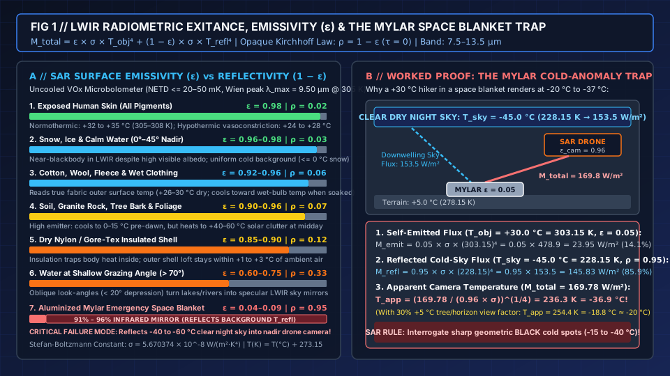
Figure 1: Stefan-Boltzmann LWIR radiometric exitance scale comparing high-emissivity human skin (ε = 0.98) and natural terrain (ε = 0.90–0.98) against low-emissivity aluminized Mylar emergency space blankets (ε = 0.04–0.09), with step-by-step proof of the -20 °C to -37 °C cold-sky reflection anomaly.
SAR surface emissivity (ε) and reflectivity (1 − ε) reference table
Because T_app blends true surface temperature T_obj with reflected background T_refl in proportion to ε and 1 − ε, SAR flight crews must know the LWIR optical properties of every material in the search sector:
| Surface or Target Material | LWIR Emissivity (ε at 8–14 µm) |
LWIR Reflectivity (ρ = 1 − ε) |
Typical True Surface Temp (T_obj) in Field SAR |
Operational Thermal Drone SAR Implication |
|---|---|---|---|---|
1. Exposed Human Skin (All melanin & skin tones) |
0.98 (0.97 – 0.99) |
0.02 (2% reflective) |
+32 °C to +35 °C (305–308 K) normothermic face/scalp/hands; drops to +24 °C to +28 °C under cold-induced peripheral vasoconstriction |
Near-perfect blackbody emitter (completely independent of visible skin pigmentation). Uncovered head, neck, and hands are the highest-contrast biological emitters. |
| 2. Cotton, Wool, Fleece & Wet Clothing | 0.92 – 0.96 |
0.04 – 0.08 (4%–8% reflective) |
Dry uninsulated shirt: +26 °C to +30 °C; rain- or sweat-soaked fabric cools rapidly toward ambient wet-bulb temperature (+5 °C to +15 °C) |
High emissivity means the sensor reads true outer fabric temperature—which can sit at or below ambient air if evaporative cooling is active. |
3. Dry Nylon / Polyester Insulated Shell (Gore-Tex, Ripstop, Down Parka) |
0.85 – 0.90 |
0.10 – 0.15 (10%–15% reflective) |
Outer shell equilibrates within +1 °C to +3 °C of ambient air (e.g., +6 °C to +8 °C shell in +5 °C night air) |
Thermal insulation masking: Technical cold-weather gear traps metabolic heat inside. Only compressed seams (shoulders, elbows, back) and an unhooded face radiate strongly above ambient. |
4. Calm Fresh or Sea Water (0°–45° Nadir vs > 70° Grazing Angle) |
0.96 – 0.98 (nadir 0°–45°)0.60 – 0.75 (> 70° grazing) |
0.02 – 0.04 (nadir)0.25 – 0.40 (> 70° oblique) |
Bulk water +4 °C to +25 °C; LWIR is absorbed within the top 10 to 50 µm surface skin layer (zero subsurface penetration) |
Look straight down (-45° to -90° gimbal pitch) over water to spot a swimmer’s head. At shallow grazing angles (< 20° depression), water acts as an IR mirror reflecting cold sky or warm shoreline trees. |
| 5. Dry Soil, Granite Rock, Asphalt, Tree Bark & Green Foliage | 0.90 – 0.96 (granite/sand 0.90–0.93; bark/leaves 0.94–0.97) |
0.04 – 0.10 (4%–10% reflective) |
Pre-dawn: 0 °C to +15 °C; Sunny midday (800–1,000 W/m²): +40 °C to +60 °C on bare rock, deadfall logs, and dark soil |
High emissivity + high solar absorption makes sunlit rock and dead wood out-glow human targets from late morning until 2–4 hours after sunset. |
| 6. Snow and Ice | 0.96 – 0.98 (fresh snow ~0.98; smooth ice ~0.96) |
0.02 – 0.04 (2%–4% reflective in LWIR) |
<= 0 °C (-25 °C to 0 °C / 248–273 K) |
Despite reflecting 80%–90% of visible sunlight, snow is almost a pure blackbody absorber/emitter in LWIR (ε = 0.98), providing an ideal uniform cold background for winter SAR. |
| 7. Aluminized Mylar Emergency Space Blanket / Polished Foil | 0.04 – 0.09 (vapor-deposited Al ~0.05) |
0.91 – 0.96 (91%–96% IR mirror!) |
True blanket contact temp: +25 °C to +32 °C; Apparent LWIR temp under clear night sky: -20 °C to -37 °C! |
CRITICAL SAR FAILURE MODE: Reflects the -40 °C to -60 °C zenith night sky into the nadir drone sensor, turning a warm survivor into an ice-cold black anomaly! |
Worked radiometric proof: the aluminized Mylar space blanket failure mode
Wilderness survival kits universally pack a 50 g aluminized Mylar emergency space blanket (polyethylene terephthalate film vacuum-coated with vapor-deposited metallic aluminum) and instruct lost or injured hikers to wrap themselves inside it to prevent radiative heat loss. That exact physical property—ε = 0.04 to 0.09 (91% to 96% LWIR reflectivity)—creates a severe failure mode for aerial thermal search teams who do not understand Kirchhoff reflection.
Consider an injured hiker lying in an open mountain meadow or forest clearing at night with the following physical boundary conditions:
- True Hiker / Blanket Surface Temperature (
T_obj):+30.0 °C = 303.15 K(warm body in contact with the inner Mylar surface). - Space Blanket Optical Constants: LWIR emissivity
ε = 0.05; LWIR reflectivityρ = 1 − ε = 0.95. - Surrounding Meadow Ground Temperature (
T_ground):+5.0 °C = 278.15 K(ε_ground = 0.95). - Clear, Dry Night Sky Effective LWIR Temperature (
T_sky):-45.0 °C = 228.15 K(under clear, low-humidity mountain skies, downwelling atmospheric8–14 µmradiance corresponds to an effective blackbody temperature of-40 °C to -60 °C; under low, thick stratus cloud cover,T_skywarms to-2 °C to +5 °C). - Drone Thermal Camera Assumed Emissivity (
ε_cam):0.96(standard radiometric menu default).
Executing the four-step Stefan-Boltzmann calculation (σ = 5.670374 × 10^-8 W/(m²·K⁴)):
- Step 1 — Self-Emitted Thermal Flux from the
+30.0 °CBlanket (M_emitted): A blackbody at303.15 Kwould emitσ × (303.15)⁴ = 478.90 W/m². Because the aluminized Mylar surface hasε = 0.05, its true self-emitted radiant exitance is suppressed by95%:M_emitted = ε × σ × T_obj⁴ = 0.05 × (5.670374 × 10^-8) × (303.15 K)⁴ = 0.05 × 478.90 = 23.95 W/m² - Step 2 — Reflected Cold-Sky Flux Bouncing Off the Blanket into the Nadir Drone Lens (
M_reflected): Downwelling zenith sky irradiance atT_sky = 228.15 K(-45.0 °C) isσ × (228.15)⁴ = 153.51 W/m². With reflectivity1 − ε = 0.95, the blanket reflects95%of that cold sky radiation upward into the drone camera:M_reflected = (1 − ε) × σ × T_sky⁴ = 0.95 × 153.51 = 145.83 W/m² - Step 3 — Total Radiant Exitance Reaching the Sensor (
M_total) vs Meadow Background (M_ground):M_total = M_emitted + M_reflected = 23.95 + 145.83 = 169.78 W/m²Notice that85.9%of the infrared energy reaching the drone comes from the freezing night sky, and only14.1%comes from the hiker! By contrast, the+5.0 °C(278.15 K) meadow grass around the hiker (ε = 0.95) emits0.95 × 339.1 + 0.05 × 153.5 = 329.8 W/m²—nearly twice as much LWIR energy as the Mylar-wrapped hiker. - Step 4 — Apparent Temperature (
T_app) Computed by the Drone Camera (ε_cam = 0.96):T_app = ( M_total / (ε_cam × σ) )^(1/4) = ( 169.78 / (0.96 × 5.670374 × 10^-8) )^(1/4) = ( 3.1189 × 10^9 )^(1/4) = 236.31 K = -36.8 °C! (Even if crinkled blanket folds reflect a70%clear sky (-45 °C) +30%surrounding pine trees (+5 °C) hemisphere so that effective reflected radiance is0.70 × 153.5 + 0.30 × 339.1 = 209.2 W/m², total exitance isM_total = 23.95 + (0.95 × 209.2) = 222.7 W/m², which the camera displays asT_app = 252.9 K = -20.2 °C—still25 Kcolder than the+5 °Cground!)
Takeaway: If a thermal operator scans exclusively for bright white hotspots in White Hot or enables a warm isotherm (e.g., >= +20 °C), a hiker wrapped in an aluminized Mylar space blanket under a clear night sky is completely invisible as a warm target and instead renders as a sharp-edged, jet-black cold anomaly (-20 °C to -37 °C). Always brief visual observers to flag unnatural geometric cold spots (1.5–2.0 m rectangles reading 15 K to 40 K colder than ambient terrain) and inspect them for 1–3 pixels of warm exposed face (ε = 0.98) at the blanket collar.
Diurnal thermal crossover and solar loading: why time of day governs thermal POD
In our forest canopy search optimization analysis, Question 4 of our 9-point audit asks: “What time of day, temperature, and weather were behind the detection figure?” The reason time of day dominates aerial thermal Probability of Detection (POD) is governed by the surface energy balance of natural terrain under solar irradiation and radiative night cooling.
The physics of midday solar clutter (800–1,000 W/m²)
Under a clear midday sky (10:00 to 16:30 local solar time), incident shortwave solar irradiance (G_solar ≈ 800 to 1,000 W/m²) strikes exposed rock, soil, sand, asphalt, and deadfall timber. A surface with shortwave solar albedo A_sw absorbs (1 − A_sw) × G_solar (typically 650 to 880 W/m² for dark granite, basalt talus, dry soil, or weathered tree bark). While living green leaves stay relatively cool (+22 °C to +28 °C) via latent heat of evapotranspiration, dry non-transpiring materials—granite boulders, rock ledges, bare dirt trails, tree stumps, and fallen logs—heat rapidly to +40 °C to +60 °C (104 °F to 140 °F).
Meanwhile, a living human maintains a tightly regulated core temperature of +37.0 °C through perspiration and vasodilation, presenting an outer bare-skin temperature of +32 °C to +35 °C and a shaded clothing temperature of +26 °C to +32 °C. When the terrain background reaches +42 °C to +58 °C, three failure mechanisms degrade thermal SAR simultaneously:
- Thermal Contrast Inversion (
ΔT_app = -10 K to -25 K): The missing person is now physically cooler than sunlit boulders, bare soil patches, and deadfall logs (ΔT_app = T_app_target − T_app_background < 0 K). - AGC Histogram Compression: When
50 °C–60 °Crocks and22 °Cshaded canopy occupy the same camera frame, an8-bit(256-level) Automatic Gain Control histogram stretches across a38 Kdynamic range, compressing the subtle2–4 Kdifference between a+30 °Chiker and+27 °Cshaded brush into indistinguishable mid-gray noise. - Solar-Clutter False Alarm Saturation: Across a
1,200 × 2,400 ft(366 × 732 m,26.8 hectare) pine and mixed-hardwood sector—the exact dimensions specified for Challenge 3.1 FastFind in the 2021–2022 First Responder UAS Triple Challenge Archive—thousands of sunlit pine stumps, rock outcrops, and bare dirt patches reach+38 °C to +52 °C, generating human-sized thermal blobs that force the aircraft to break off grid legs for visual hover verification. Indeed, during the June 2022 FastFind live finals near Starkville, Mississippi, extreme summer heat and solar thermal loading forced competition organizers to reschedule flight events due to a heat advisory.
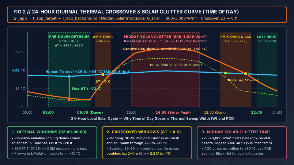
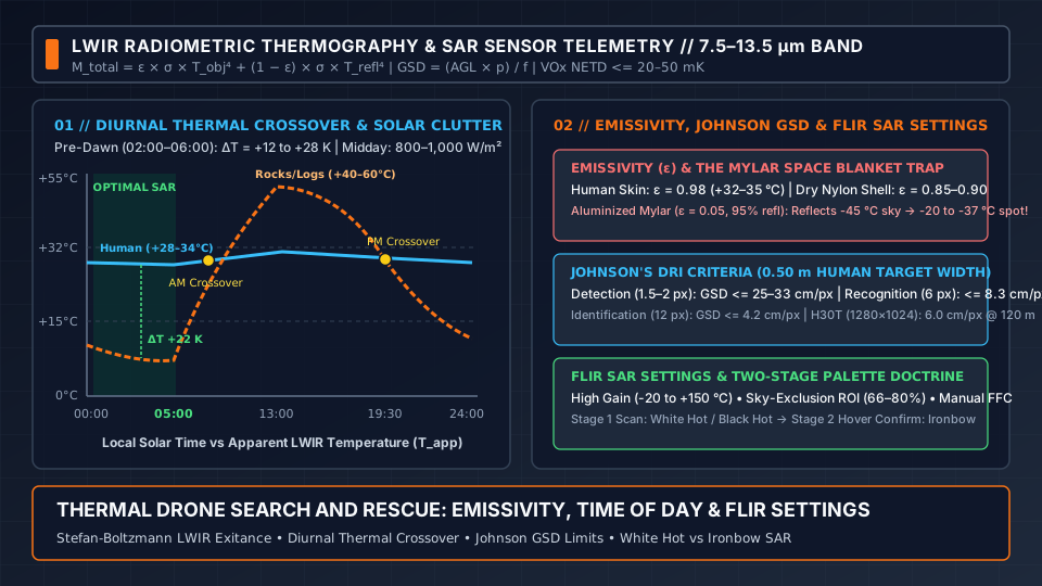
Figure 2: 24-hour diurnal thermal contrast curve comparing human target apparent temperature (+26 °C to +34 °C) against low-mass brush/soil and high-thermal-inertia granite boulders across Pre-Dawn Optimum (02:00–06:00), Morning Crossover, Midday Solar Clutter, and Evening Rock Lag.
The two daily diurnal thermal crossover windows (ΔT_app -> 0 K)
Thermal Crossover is the diurnal transition period when the apparent radiometric temperature of the background terrain equals the apparent temperature of the human target:
ΔT_app = T_app_target − T_app_background -> 0 K (contrast collapse when |ΔT_app| < 1.0 to 1.5 K)
Because different terrain materials possess vastly different volumetric heat capacities (C_v = ρ_m × c_p, in MJ/(m³·K)) and thermal effusivities (e = √(k × ρ_m × c_p), in J/(m²·K·s^(1/2))), thermal crossover does not occur at a single instant; it sweeps across the landscape in two daily windows:
- Morning Thermal Crossover (
~30 to 90 minutesafter local sunrise): At dawn, soil, brush, and rock sit at their daily minimum temperature (0 °C to +15 °C), while the missing person’s skin and uninsulated clothing sit at+26 °C to +34 °C(strong positive contrast ΔT_app = +12 K to +28 K). Once direct sunlight strikes the terrain (starting earliest on east- and southeast-facing slopes), low-thermal-mass surfaces—dry grass, pine needle litter, brush, and thin surface soil (C_v ≈ 0.8–1.3 MJ/(m³·K))—warm rapidly at10 °C to 20 °C per hour. Between30 and 90 minutesafter sunrise, background apparent temperature passes directly through the+26 °C to +33 °Chuman target band (ΔT_app = 0 K), causing a stationary subject to vanish into the background before contrast inverts. - Evening Thermal Crossover & High-Inertia Rock Lag (
~30 to 90 minutesafter sunset for brush;2 to 4 hoursfor rock): After local sunset, shortwave solar irradiance drops to zero (G_solar = 0 W/m²) and the terrain cools via net longwave radiative exitance (ε × σ × T_ground⁴ − ε × σ × T_sky⁴) and convective air exchange. Low-mass grass, leaves, and surface duff cool below+25 °Cwithin30 to 90 minutesafter sunset. However, dense granite boulders, cliff faces, basalt talus, and asphalt roads possess high volumetric heat capacity (C_v ≈ 2.1 to 2.5 MJ/(m³·K)) and high thermal effusivity (e ≈ 2,200 to 2,800 J/(m²·K·s^(1/2))vs~400–700for dry soil). Deeply heated boulders conduct stored midday heat slowly to their outer surface, remaining at+28 °C to +38 °Cfor2 to 4 hoursafter sunset. During this2–4 hourpost-sunset lag window, every0.5–1.0 mboulder radiates at the exact apparent temperature of a curled human survivor.
24-hour diurnal thermal SAR flight-window schedule
| Diurnal Flight Window (Local Solar Time) | Human Target Apparent Temp (T_app_target) |
Terrain Background Apparent Temp (T_app_bg) |
Net Thermal Contrast (ΔT_app) |
Solar & Rock Clutter Severity | Tactical SAR Flight & Sensor Recommendation |
|---|---|---|---|---|---|
1. Pre-Dawn Optimum (02:00 – 06:00, Until Sunrise) |
+26 °C to +34 °C (skin & clothing) |
0 °C to +15 °C (all rock & soil fully cooled) |
+12 K to +28 K (Maximum Positive Contrast) |
Minimal (only live wildlife/livestock remain warm) |
Primary thermal SAR window. Fly wide-area parallel sweeps in White Hot + High Gain. All prior-day rock heat has dissipated. |
2. Morning Crossover (Sunrise + 30 min to + 90 min) |
+27 °C to +34 °C |
Rising rapidly from +15 °C through +35 °C |
0 K to ±2 K (Contrast Collapse) |
High transition clutter (east slopes match human temp) |
Worst thermal window. Rely on high-resolution visible RGB zoom camera (EO) or delay/tighten track spacing S. |
3. Midday Solar Loading (10:00 – 16:30 Clear Sky) |
+28 °C to +35 °C |
+40 °C to +60 °C (rock, sand, bare soil, logs); +22–28 °C (green canopy) |
-5 K to -25 K (Inverted in open terrain) |
Severe (Thousands of sun-heated false positives) |
Poor in open/rocky terrain. Use RGB + AI detection, or switch to Black Hot to spot cool human silhouettes against +50 °C sand/rock. Viable under dense closed canopy or heavy overcast. |
4. Evening Crossover & Rock Lag (Sunset to Sunset + 2–4 hr) |
+26 °C to +34 °C |
Grass cools to +15–22 °C, but boulders stay +28–38 °C for 2–4 hr |
0 K to ±3 K on rock (+8 K on grass) |
Moderate-to-High (warm boulders mimic curled hikers) |
High false-alarm regime. Interrogate hotspots in hover using Ironbow (checking for concentric body gradient vs uniform rock) + NIR/starlight night camera. |
5. Late Night Stabilization (22:00 – 02:00) |
+25 °C to +33 °C |
+4 °C to +18 °C (most boulder heat bled off) |
+10 K to +22 K (High Positive Contrast) |
Low | Second-best thermal SAR window. Verify 14 CFR § 107.29 night strobe (>= 3 SM) and pre-warm batteries to >= +15 °C. |
Regulatory and propulsion prerequisites for Pre-Dawn (02:00–06:00) SAR flights
Because the highest-POD thermal window occurs in total darkness between 22:00 and 06:00, public-safety UAS teams must satisfy two operational requirements before launching night sorties:
- FAA Night Flight Compliance (
14 CFR § 107.29): Under federal aviation regulations (14 CFR § 107.29(a)), operating a small unmanned aircraft at night (or during civil twilight) requires that: (a) the Remote Pilot in Command (RPIC) has completed the updated FAA initial knowledge test or recurrent training covering night physiology and night visual illusions; and (b) the aircraft is equipped with illuminated anti-collision lighting visible for at least3 statute miles(4.8 km) with a flash rate sufficient to avoid a collision. If a nocturnal forest search requires flying Beyond Visual Line of Sight (BVLOS,14 CFR § 107.31) or above400 ft AGL, the agency must submit an expedited waiver request using our Emergency Drone Authorization (SGI) Checklist. - Cold Pre-Dawn Battery Pre-Heating (
>= +15 °C) &Gimbal Mass Budget: Pre-dawn mountain air (02:00–06:00) represents the coldest ambient temperature of the 24-hour cycle. As quantified in our drone payload capacity and flight-time degradation curve analysis, launching a DJI Matrice 350 RTK with a920 gZenmuse H30T thermal gimbal (7.40 kgtotal takeoff weight) increases hover power by+22.3%under theM_total^(3/2)actuator disk law, cutting operational flight time (20% SoCreserve) from42–44 minutesto34–36 minutes(or 28–31 minuteswhen paired with a spotlight or LiDAR). Furthermore, if lithium battery cells are cold-soaked below+15 °Cat03:00, internal resistanceR_intspikes2x to 6x, risking an instantaneousI_bat × R_intlow-voltage cutoff (< 3.25 V/cell) mid-sweep. Always pre-heat batteries to>= +15 °C to +20 °Cbefore pre-dawn launch.
Takeaway: Schedule primary wide-area thermal SAR sweeps for the 02:00–06:00 pre-dawn or 22:00–02:00 late-night windows (ΔT = +10 K to +28 K), avoid relying on thermal contrast alone during the 30–90 minute post-sunrise and post-sunset crossover windows, and account for 2 to 4 hours of granite boulder thermal lag after dusk.
Johnson’s criteria and Ground Sample Distance (GSD): matching flight altitude to sensor resolution
Even during the 02:00–06:00 pre-dawn optimum with +20 K of thermal contrast, a thermal camera cannot classify a missing person if the aircraft flies so high that the human body subtends less than a single detector pixel. Compared to visible RGB drone cameras (20 MP to 48 MP, 5280 × 3956 pixels), uncooled LWIR thermal arrays have 15x to 145x fewer total pixels (640 × 512 = 327,680 pixels, or 1280 × 1024 = 1,310,720 pixels). Spatial resolution is therefore the primary geometric bottleneck in thermal search planning.
Deriving LWIR Ground Sample Distance (GSD)
By pinhole camera geometry, a detector with pixel pitch p_pixel (m, the center-to-center distance between microbolometer bridges, typically 12 µm = 1.2 × 10^-5 m or 8 µm = 8.0 × 10^-6 m) and lens focal length f (m or mm) has an Instantaneous Field of View (IFOV, in radians or milliradians) of:
IFOV (rad) = p_pixel / f
At aircraft altitude AGL (meters Above Ground Level) looking straight down (nadir, 90° depression), the linear ground footprint projected onto a single pixel is the Ground Sample Distance (GSD):
GSD = (AGL × p_pixel) / f = AGL × IFOV
(Engineering note for oblique searches: when the gimbal is pitched at depression angle θ_dep below the horizon—such as θ_dep = 45°—slant range increases to R_slant = AGL / sin(θ_dep). Across-track GSD increases by 1 / sin(θ_dep) (1.41x at 45°), while along-track GSD stretches by 1 / sin²(θ_dep) (2.00x at 45°).)
Across a detector array of horizontal width N_x pixels (640 or 1280), the total nadir ground swath width W_swath at altitude AGL is:
W_swath = N_x × GSD = (N_x × AGL × p_pixel) / f
Johnson’s DRI criteria (Detection, Recognition, Identification) for a 0.50 m human target
Formulated by John Johnson (1958) for electro-optical and infrared target acquisition, Johnson’s Criteria define the minimum number of resolved spatial cycles (line pairs, lp, where 1 line pair = 2 pixels by Nyquist sampling) required across the minimum critical dimension (d_crit) of a target to achieve a 50% probability (N_50) of performing three progressively stricter discrimination tasks.
For an aerial search looking down at a standing, seated, kneeling, or curled missing person, the critical minimum target width across the shoulders and torso is d_crit = 0.50 m (50 cm) (whereas an unoccluded prone adult lying flat presents 0.50 m × 1.75 m, yielding a two-dimensional characteristic dimension d_char = √(0.50 × 1.75) = 0.94 m). Applying the conservative d_crit = 0.50 m standard (which protects against missed detections when a subject is sitting against a tree trunk, curled for warmth, or partially occluded by canopy gaps) establishes three mandatory GSD ceilings:
GSD_max = d_crit / N_pixels_required = 0.50 m / N_pixels_required
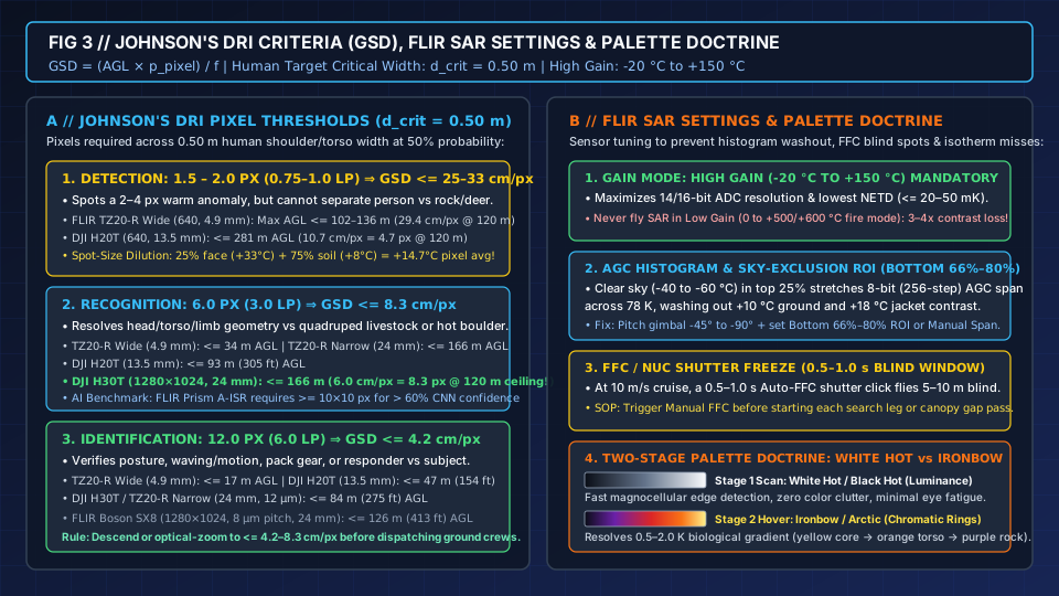
Figure 3: Johnson's Detection, Recognition, and Identification (DRI) pixel thresholds and maximum flight altitudes across 640×512 and 1280×1024 LWIR payloads, paired with FLIR SAR camera configuration rules and the Two-Stage Palette Doctrine.
| Johnson DRI Discrimination Level | Required Line Pairs (N_50) Across 0.50 m |
Required Pixels Across 0.50 m (2D Pixel Footprint) |
Maximum Allowable GSD (0.50 m / N_px) |
Max AGL — FLIR TZ20-R Wide (640, 12 µm, f = 4.9 mm) |
Max AGL — DJI Zenmuse H20T (640, 12 µm, f = 13.5 mm) |
Max AGL — DJI H30T / TZ20-R Narrow (1280/640, 12 µm, f = 24 mm) |
Max AGL — FLIR Boson SX8 (1280, 8 µm, f = 24 mm) |
Operational SAR Meaning & AI Benchmark |
|---|---|---|---|---|---|---|---|---|
1. Detection (Spot a thermal anomaly) |
0.75 – 1.0 lp |
1.5 – 2.0 px (~3 to 6 total 2D pixels on target) |
<= 25.0 – 33.3 cm/px (0.25–0.33 m/px) |
<= 102 – 136 m (335–446 ft; at 120 m, GSD = 29.4 cm/px = 1.7 px) |
<= 281 – 375 m (at 120 m, GSD = 10.7 cm/px = 4.7 px) |
<= 500 – 666 m (at 120 m, GSD = 6.0 cm/px = 8.3 px) |
<= 750 – 1,000 m (at 120 m, GSD = 4.0 cm/px = 12.5 px) |
Operator sees a 2–4 px bright speck ("something warm is there"), but cannot distinguish a human from a warm rock, stump, sheep, or deer. |
2. Recognition (Classify class: Human vs Rock/Quadruped) |
3.0 lp |
6.0 px (~6 × 18 px prone or ~7 × 7 px seated) |
<= 8.3 cm/px (0.083 m/px) |
<= 34 m (111 ft AGL — requires switching to 24 mm narrow lens!) |
<= 93 m (305 ft AGL) |
<= 166 m (545 ft AGL — exceeds full 120 m / 400 ft Part 107 ceiling!) |
<= 249 m (817 ft AGL) |
Resolves head/shoulder/limb geometry vs deer or boulder. (Note: Teledyne FLIR Prism A-ISR CNN specifies >= 10 × 10 px for > 60% automated classification confidence.) |
3. Identification (Verify posture, motion, gear, or responder) |
6.0 lp |
12.0 px (~12 × 35 px prone) |
<= 4.2 cm/px (0.042 m/px) |
<= 17 m (56 ft AGL) |
<= 47 m (154 ft AGL) |
<= 84 m (275 ft AGL) |
<= 126 m (413 ft AGL — full Part 107 Identification!) |
Confirms whether the person is waving, walking, lying motionless, carrying a pack, or accompanied by a rescue dog. |
Worked altitude vs swath trade-off: why 640×512 wide lenses fail at 120 m AGL
Examine what happens when a pilot flies at the standard FAA Part 107 ceiling of AGL = 120 m (394 ft) over a forest clearing:
- Case A — Wide-Angle
640 × 512Sensor (FLIR Vue TZ20-R Wide,p_pixel = 12 µm,f = 4.9 mm,95° HFOV):GSD = (120 m × 12 × 10^-6 m) / 0.0049 m = 0.2939 m/px = 29.4 cm/pxAcross a0.50 mseated or standing hiker,0.50 m / 0.2939 m/px = 1.70 pixels! While the95°wide lens covers a huge640 × 0.2939 m = 188.1 mground swath in a single pass, the hiker occupies fewer than2 pixels, sitting on the razor’s edge of Johnson Detection (1.5–2.0 px). Any partial leaf occlusion or spot-size averaging erases the target completely. That is why the TZ20-R pairs its4.9 mmwide Boson with a second24 mmnarrow Boson (GSD = 6.0 cm/pxat120 m=8.3 pixelsacross0.50 m) for immediate5xoptical zoom Recognition. - Case B — Medium-FOV
640 × 512Sensor (DJI Zenmuse H20T,p_pixel = 12 µm,f = 13.5 mm,~33.4° HFOV): At120 mAGL,GSD = (120 × 12 × 10^-6) / 0.0135 = 0.1067 m/px = 10.7 cm/px(swath width = 640 × 0.1067 = 68.3 m). A0.50 mtarget spans0.50 / 0.1067 = 4.69 pixels—well above Detection (2.0 px), but slightly below the6.0-pixelRecognition threshold. Lowering flight altitude from120 mto90 m(295 ft) AGL tightensGSDto8.0 cm/px(6.25 pixelsacross0.50 m,51.2 mswath), achieving full human Recognition during the primary grid sweep. - Case C — High-Definition
1280 × 1024SXGA Sensor (DJI Zenmuse H30T,p_pixel = 12 µm,f = 24.0 mm,~36.2° HFOV): At120 mAGL,GSD = (120 × 12 × 10^-6) / 0.024 = 0.060 m/px = 6.0 cm/px, while the1,280-pixelhorizontal array covers a76.8 mnadir swath (1280 × 0.060 m). Across a0.50 mhuman target, the H30T puts8.33 pixels(0.50 / 0.060) on the subject at120 mAGL—exceeding both the6.0-pixelhuman Recognition threshold and approaching the>= 10 × 10 pixelembedded-vision CNN threshold documented in our Teledyne FLIR Prism A-ISR integration checklist, without sacrificing swath widthW!
Takeaway: Size search altitude AGL using GSD = (AGL × p_pixel) / f so a 0.50 m human target spans at least 2.0 pixels (GSD <= 25 cm/px) for initial detection and 6.0 pixels (GSD <= 8.3 cm/px) for class recognition before committing ground teams.
FLIR SAR settings: Gain mode, AGC ROI, FFC shutter calibration, and the isotherm dilution trap
Mounting a <= 20–50 mK VOx sensor on an airframe does not guarantee target visibility if the camera’s internal signal-processing pipeline (flir sar settings) crushes dynamic range, freezes the video feed over a canopy gap, or masks out the victim with an improperly configured temperature threshold. Before launching any missing-person sortie on a Teledyne FLIR Boson/Tau2/Vue TZ20-R or DJI Zenmuse H20T/H30T payload, configure these four core parameters:
1. Radiometric Gain Mode: High Gain (-20 °C to +150 °C) vs Low Gain (0 °C to +500/+600 °C)
Radiometric thermal cameras provide two selectable hardware pre-amplifier and analog-to-digital converter (ADC) quantization ranges:
- High Gain Mode (
-20 °C to +150 °C/-4 °F to +302 °F): Mandatory for all Search and Rescue operations. High Gain allocates the full14-bit(16,384counts) or16-bit(65,536counts) ADC dynamic range across a narrow170 Kbiological and environmental temperature window, delivering the detector’s rated minimum noise floor (NETD <= 20 mK to 50 mK). - Low Gain Mode (
0 °C to +500 °Con H20T/Boson, or0 °C to +600 °Con H30T): Engineered strictly for structural firefighting, wildland fire perimeter mapping, and industrial smelter/substation inspections where+400 °Cflames would saturate the High Gain pre-amplifier. If a pilot leaves a dual-use public-safety drone in Low Gain Mode from a prior structure-fire call and launches on a wilderness SAR mission, effective thermal sensitivity degrades by3x to 4x(NETD worsens to ~100–160 mK), washing out low-contrast clothed subjects under tree canopy.
2. Automatic Gain Control (AGC), 8-Bit Histogram Stretch, and Sky-Exclusion ROI
While the VOx sensor core digitizes radiant flux at 14-bit or 16-bit depth, the pilot’s controller monitor (DJI RC Plus, Smart Controller, or ground station display) renders an 8-bit (256 luminance or color levels) video stream. The camera’s Automatic Gain Control (AGC) algorithm continuously analyzes the scene histogram (Linear, Histogram Equalization, or Plateau Equalization) and maps the coldest pixel in the frame to display level 0 and the warmest pixel to display level 255.
The Horizon Sky & Hot-Spot AGC Washout Trap:
Suppose a pilot flies a night search over +10.0 °C forest terrain searching for a hiker whose insulated jacket exterior reads +18.0 °C (an 8.0 K scene span).
- Correct Framing (
Nadir / No Sky in Frame): When the frame contains only terrain (+10 °C to +18 °C), linear AGC maps256gray levels across8.0 K(0.031 K per gray step), rendering the+18 °Chiker at bright level255and the+10 °Cforest floor at dark level0. - Incorrect Framing (
Horizon Sky in Top 25% of Frame): If the pilot pitches the gimbal up to-15°so the top quarter of the image includes the clear zenith/horizon night sky (T_sky = -50.0 °C), the scene minimum plunges from+10 °Cto-50 °C(a 68.0 K total span). The AGC now wastes display levels0 through 225(88%of the entire8-bitgreyscale!) on empty air between-50 °Cand+10 °C, compressing the entire+10 °C to +18 °Cforest floor and hiker into levels226 through 255(a washed-out, glaring white/light-gray blob)! Conversely, flying past a+250 °Cvehicle exhaust pipe or campfire crushes the+10 °C to +18 °Cterrain into pitch-black levels0 through 12.
Three Field Fixes for AGC Washout:
- Gimbal Depression Discipline (
-45° to -90° Nadir): Keep the horizon completely out of the thermal frame during grid sweeps; pitch between-60° and -90°over forest canopy (where near-nadir look angles also maximize canopy gap penetration) and-35° to -60°in open meadows. - Sky-Exclusion AGC Region of Interest (
ROI = Bottom 66% or 80%): On Teledyne FLIR Boson and Tau cores, set the AGCROIregister to the bottom66%or80%of the sensor array so the histogram algorithm ignores cold sky pixels in the top row band when computingMin/Maxdisplay gain. Additionally, cap Plateau Value (max pixels per bin) and reduce DDE (Digital Detail Enhancement) sharpening at night so high-frequency sensor grain is not amplified into false snow noise. - Locked Manual Level & Span (
Manual Windowing): When searching uniform terrain, switch AGC fromAutoto Manual Level & Span and lock the display floor2 °Cbelow ambient ground temperature and the ceiling15–20 °Cabove ground (e.g., Manual Span = +8 °C to +26 °C), guaranteeing constant contrast regardless of sky or hot-rock intrusions.
3. Flat-Field Correction (FFC / NUC) Shutter Calibration and the 1-Second Blind Spot
Because the 327,680 (640×512) or 1,310,720 (1280×1024) microbolometer elements on an uncooled VOx array have slight manufacturing tolerances and experience non-uniform convective cooling across the Germanium lens barrel during forward flight, pixel resistance offsets drift over time—producing fixed-pattern vertical striping, corner vignetting (thermal halo), and radiometric drift. To restore uniformity, the camera periodically executes a Flat-Field Correction (FFC, also called Non-Uniformity Correction, NUC): a miniature electromechanical paddle shutter swings across the detector plane for 0.5 to 1.0 seconds, presenting a uniform isothermal reference surface so the processor can zero out pixel-to-pixel offset tables.
The Mid-Sweep Frame Freeze Hazard:
During that 0.5 to 1.0 second mechanical shutter actuation, the live thermal video stream freezes completely. If a search drone is cruising a parallel track leg at V = 10 m/s (22.4 mph / 19.4 kt) over a pine forest where canopy gaps open for only 0.3 to 0.8 seconds, an uncommanded Auto-FFC shutter click (which triggers automatically every 1 to 3 minutes or whenever internal housing temperature shifts by 1–2 °C) causes the aircraft to fly 5.0 to 10.0 meters (16 to 33 ft) completely blind—easily skipping right over a missing person!
Mandatory SAR FFC Protocol:
- Trigger a Manual FFC Prior to Every Search Leg: Press the controller’s Manual FFC (
calibration) shortcut button during the turn-around bank outside the search boundary (or immediately before descending over a high-probability datum), resetting theAuto-FFCtimer and guaranteeing an uninterrupted, low-noise video feed down the entire search leg. - Allow
5–7 Minutesof Post-Power-On Thermal Stabilization: When an aircraft is moved from a warm+22 °Ccommand vehicle into+2 °Cpre-dawn air, the camera chassis cools rapidly during the first5 minutes, triggering frequent FFC cycles; power on the gimbal during pre-flight briefing so the core stabilizes before takeoff.
4. Temperature Isotherms and the Spot-Size Ratio (SSR) Pixel Dilution Trap
One of the most persistent myths in novice drone SAR training is setting a narrow Human Body Temperature Isotherm (e.g., Lower Threshold = +30 °C, Upper Threshold = +37 °C) so the camera highlights only pixels reading 30–37 °C in bright red or yellow against a grayscale background. In real wilderness search and rescue at 60–120 m AGL, relying on a +30 °C to +37 °C isotherm is a catastrophic error that masks real victims.
Here is the exact physics of why a living human (+37 °C core, +33 °C bare face) almost never registers at +30 °C to +37 °C from search altitude:
- Clothing Insulation & Hypothermic Vasoconstriction: As shown in our Emissivity Table, a dry fleece or nylon shell jacket equilibrates to
+6 °C to +18 °Cin cool air, and exposed hands/face drop to+24 °C to +28 °Cunder cold vasoconstriction. - Spot-Size Ratio (
SSR) / Partial-Pixel Area Averaging (The Dilution Equation): A single microbolometer pixel does not measure the hottest point inside its footprint; it integrates the area-weighted average radiant exitance (M_pixel) across its entireGSD × GSDground square (or 3×3 pixel Airy diffraction blur spot):M_pixel = Σ [ (A_i / A_pixel) × M_i ]Worked Dilution Calculation: Suppose a DJI Zenmuse H20T (GSD = 10.7 cm/pxat120 mAGL, or20.0 cm/pxoblique/wide) views a hiker lying on a+8.0 °C(281.15 K,M_bg = 354.1 W/m²) forest floor. The hiker’s upturned bare face (15 cm × 15 cm = 225 cm²atT_face = +33.0 °C = 306.15 K,M_face = 498.1 W/m²) falls across a2 × 2pixel cluster (where each 20 cm × 20 cm pixel has area A_pixel = 400 cm²), so that the best single pixel is filled25%by warm face (100 cm²) and75%by+8.0 °Cpine needles (300 cm²):M_pixel = (0.25 × 498.1 W/m²) + (0.75 × 354.1 W/m²) = 124.53 + 265.58 = 390.11 W/m²ConvertingM_pixel = 390.11 W/m²back to apparent temperature (T_pixel = (390.11 / σ)^(1/4)):T_pixel = 288.0 K = +14.8 °C(58.6 °F)! Because of25% / 75%pixel-area averaging (plus2–4 °Cof120 matmospheric path attenuation), the+33.0 °Cface reads as+14.8 °Con the drone’s radiometric spot meter and isotherm filter—falling15.2 °Cbelow a+30 °Cisotherm floor!
Takeaway: Lock the thermal core in High Gain (-20 °C to +150 °C), keep the cold horizon sky out of the AGC histogram via -45° to -90° gimbal depression or a bottom 66%–80% ROI, trigger Manual FFC before entering each grid leg, and never use a narrow +30 °C to +37 °C human-skin isotherm at search altitude where partial-pixel dilution averages human targets down to +14 °C–+24 °C.
White Hot vs Ironbow SAR: the two-stage thermal color palette doctrine
Every radiometric drone payload (FLIR Boson/Vue TZ20-R, DJI H20T/H30T) offers a menu of 8 to 10 lookup-table (LUT) color palettes that map 8-bit (0–255) temperature values to screen pixels. In public-safety aviation, choosing between white hot vs ironbow sar is not an aesthetic preference; it is governed by human neuro-visual perception and follows a strict Two-Stage Thermal Palette Doctrine:
-
Stage 1 — Wide-Area Search Scanning (
Aircraft Moving at 5–12 m/s): Monochrome Luminance (White HotorBlack HotOnly) When a visual observer scans a moving video feed for30 to 40 minutestrying to spot a1.5 to 4 pixelanomaly emerging briefly between pine branches, the human retina and visual cortex rely on the magnocellular (M) luminance pathway. The magnocellular pathway has high temporal resolution (fast motion response) and high spatial contrast sensitivity for achromatic brightness gradients (luminance), whereas the parvocellular (P) chromatic pathway has lower temporal bandwidth and requires larger pixel areas (>= 6–10 pixels) to resolve color hue transitions.- Flying a fast grid sweep in a multi-color palette like
IronboworRainbowturns every1–2 Ktemperature ripple across tree bark, soil mounds, and rock ledges into a kaleidoscope of purple, magenta, red, and orange bands (chromatic clutter / false color edges). Within10 minutes, chromatic clutter induces severe visual cortex fatigue and masks tiny2-pixeltargets. - Stage 1 Rule: Always scan wide-area search grids in
White Hot(night, pre-dawn, under forest canopy, or over water) orBlack Hot(bright daytime screen glare, snowfields, or inverted midday hot desert/rock where a+32 °Chuman appears as a cool light-gray silhouette against+50 °Cblack ground).
- Flying a fast grid sweep in a multi-color palette like
-
Stage 2 — Stationary Hover Confirmation & Target Interrogation (
Aircraft Paused Over Candidate Anomaly): Chromatic Pseudo-Color (Ironbow,Arctic, orRainbow HC) Once the pilot spots a candidate anomaly inWhite HotorBlack Hot, pauses the aircraft in hover, and zooms/descends to achieve Recognition (>= 6.0 pixels,GSD <= 8.3 cm/px), monochrome white pixels near the top of the histogram often saturate (blooming), making a+32 °Ccurled hiker look identical to a+32 °Csun-warmed granite boulder.- Stage 2 Rule: Switch the palette to
Ironbow(IronRed) while hovering over the target. BecauseIronbowdistributes intermediate temperatures across distinct chromatic hues (Black/Purple cold background -> Magenta/Red outer boundary -> Orange mid-zone -> Yellow/White hot core), it renders0.5 K to 2.0 Kinternal thermal structure as clear concentric color rings:- Biological Target (Human or Mammal): Displays an asymmetric, core-peaked biological heat gradient—a bright white/yellow hotspot at the uninsulated head, neck, or armpits (
+32–34 °C), surrounded by an orange/red insulated torso (+20–26 °C), magenta extremities, and a sharp drop-off to the purple/black ground. - Inanimate False Alarm (Cooling Boulder or Stump): Displays a flat isothermal plateau or a smooth, one-sided solar-aspect gradient (
warmest on the southwest sun-facing side, cooling smoothly toward the shaded northeast side) with zero head/limb anatomical symmetry.
- Biological Target (Human or Mammal): Displays an asymmetric, core-peaked biological heat gradient—a bright white/yellow hotspot at the uninsulated head, neck, or armpits (
- Stage 2 Rule: Switch the palette to
| Thermal Palette Name | LUT Mapping Structure (Cold -> Mid -> Hot) |
Tactical SAR Stage & Role | Human Visual Perception & Contrast Advantage | Primary Deployment Environment & Limitations |
|---|---|---|---|---|
1. White Hot (Monochrome Luminance) |
0 = Black (Cold) → Linear Gray → 255 = Pure White (Hot) |
Stage 1 Primary Wide-Area Search Palette (Night, Pre-Dawn & Canopy) |
Drives fast magnocellular (M-pathway) luminance edge detection; zero chromatic false edges; lowest cognitive and ocular fatigue over 35+ min sorties |
Default SAR search palette for pre-dawn (02:00–06:00), late night, forest canopy gap scanning, and nadir maritime/river searches |
2. Black Hot (Inverted Monochrome Luminance) |
0 = White (Cold) → Linear Gray → 255 = Pure Black (Hot) |
Stage 1 Primary Wide-Area Search Palette (Daytime Glare, Snow & Hot Desert) |
Prevents white-pixel screen irradiation/blooming glare in bright daylight; preserves terrain structural detail; highlights cool targets as white silhouettes in +50 °C desert |
Daytime searches, snow/glacier SAR, and inverted midday rock/sand searches where background (+50 °C black) is hotter than the human (+32 °C light gray) |
3. Ironbow (IronRed) (Monotonic Chromatic + Luminance) |
Black/Dark Purple (Cold) → Red/Orange (Mid) → Yellow/White (Hot) |
Stage 2 Hover Confirmation & Interrogation Palette (Never for fast grid scanning) |
Separates 0.5–2.0 K internal thermal gradients into concentric color rings without losing overall dark-to-bright luminance ordering |
Stationary hover interrogation to distinguish a human’s concentric head/torso/limb heat gradient from a uniformly cooling boulder or livestock |
4. Arctic (Cool Grayscale + Warm Top-Decile Highlight) |
Blue/Cyan-Tinted Grayscale (0–85%) → Golden-Yellow/Orange (Top 10–15% Hot) |
Hybrid Low-Fatigue Scanning / Cold-Weather Palette | Preserves calm monochrome terrain texture across 85% of the histogram while automatically painting the warmest 10–15% of pixels in high-contrast gold/orange |
Effective in winter/alpine snow SAR (ε_snow = 0.98, <= 0 °C) where natural clutter is near zero and any warm biological emitter pops in gold |
5. Rainbow HC (High Contrast) |
Dark Blue → Cyan → Green → Yellow → Red → White (Multi-Hue Cycling) |
Stage 2 Low-Delta Hover Inspection Only (Isothermal Damp / Fog Scenes) |
Maximizes hue separation across tiny < 1.0 K temperature differentials when heavy clothing or wet fog compresses scene contrast |
Hover inspection only for heavily insulated subjects (dry Gore-Tex shell within +1–2 °C of ambient). Causes severe visual clutter if used while moving |
Once a candidate target is confirmed in Stage 2 hover (Ironbow concentric gradient + visible RGB optical zoom or NIR spotlight confirmation), the crew locks the target’s GPS coordinates using the gimbal’s Laser Rangefinder (LRF) and relays the radiometric R-JPEG frame and Lat/Lon/Elevation pin to ground search teams using the video-streaming and coordinate protocols in our First Responder Drone Software Handoff Checklist—or over an airborne IP mesh link when operating in cellular-denied valleys as covered in our UAS Data Relay explainer.
Takeaway: Fly Stage 1 wide-area grid sweeps in monochrome luminance (White Hot at night/canopy, Black Hot in daytime glare/snow/desert) to maximize human magnocellular edge detection speed, and switch to Ironbow only in Stage 2 stationary hover to inspect concentric 0.5–2.0 K biological heat gradients.
Pre-flight thermal SAR sensor and time-of-day verification checklist
Before launching a public-safety or wilderness thermal drone search and rescue sortie, run through this 8-step engineering and sensor-configuration gate:
| Pre-Flight Check Step | Physical Formula or Camera Register | Target Pass / Go Configuration | Failure Mode Prevented |
|---|---|---|---|
| 1. Diurnal Solar & Crossover Window Audit | ΔT_app = T_app_target − T_app_bg; check hours since sunrise/sunset & cloud cover |
Optimal: 02:00–06:00 Pre-Dawn or 22:00–02:00 Late Night (ΔT = +10 to +28 K). If flying 30–90 min post-sunrise/sunset or midday sunny (800–1,000 W/m²), pair thermal with RGB zoom or Black Hot |
Prevents planning wide-area thermal sweep widths (W) during ΔT -> 0 K crossover or +50 °C midday rock clutter |
2. Night Rules (14 CFR § 107.29) & Battery Pre-Heat |
Anti-collision strobe >= 3 SM (4.8 km); cell core temp T_cell >= +15 °C; endurance t_ops = 0.78 × t_0 × (M/M_0)^(-1.68) |
Verify >= 3 SM strobe active; pre-warm batteries to >= +15 °C to +20 °C + execute 60 s low-hover soak; budget 34–36 min ops time (M350 + H30T) |
Prevents 14 CFR § 107.29 violations and sub-zero I_bat × R_int premature low-voltage forced landings |
| 3. Radiometric Gain Mode Selection | Sensor Gain Register: High Gain vs Low Gain |
Lock High Gain Mode (-20 °C to +150 °C) (and High-Res mode on H30T) to achieve minimum NETD <= 20–50 mK |
Prevents flying a SAR mission in 0–500 °C firefighting Low Gain mode (3–4x loss of thermal sensitivity) |
4. Flight Altitude (AGL) vs Johnson DRI GSD |
GSD = (AGL × p_pixel) / f across d_crit = 0.50 m human width |
Size AGL for GSD <= 8.3 cm/px (>= 6.0 px Recognition) (<= 93 m on H20T 13.5 mm; <= 166 m on H30T 24 mm), or <= 25 cm/px (>= 2.0 px Detection) with immediate zoom confirmation |
Prevents flying a wide 4.9 mm 640×512 lens too high (< 1.5 px on target) where canopy gaps and spot-size dilution erase the subject |
5. Gimbal Pitch & AGC Sky-Exclusion ROI |
Gimbal depression -45° to -90°; AGC ROI = Bottom 66%–80% or Manual Span |
Pitch gimbal -45° to -90° (zero horizon sky in frame; 0°–45° nadir over water); set Sky-Exclusion ROI or lock Manual Span (15–20 K window around ground temp) |
Prevents -40 °C to -60 °C clear sky in the upper frame from stretching the 8-bit AGC histogram and washing out ground contrast |
6. Manual FFC (NUC) Shutter Timing Discipline |
d_blind = V_cruise × t_FFC (0.5–1.0 s shutter freeze = 5–10 m at 10 m/s) |
Allow 5 min ground thermal stabilization; trigger Manual FFC during each turn-around before entering a search leg |
Prevents an uncommanded Auto-FFC shutter click from freezing the live video feed right over a 0.5 s forest canopy gap |
| 7. Isotherm Spot-Size Dilution Gate | M_pixel = Σ (A_i / A_px) × M_i (25% +33 °C face + 75% +8 °C soil = +14.8 °C pixel avg) |
Disable narrow +30 °C to +37 °C isotherms at search altitude; if using an isotherm at night, set open threshold +3 °C to +5 °C above max background |
Prevents missing clothed, hypothermic, or partially fills-of-pixel victims whose averaged pixel temperature reads +14 °C to +24 °C |
| 8. Two-Stage Palette & Mylar Cold-Spot Briefing | Stage 1 Scan (White Hot / Black Hot) → Stage 2 Hover (Ironbow); Mylar ε = 0.05 (T_app = -20 to -37 °C) |
Scan legs in White Hot / Black Hot; switch to Ironbow in stationary hover; brief observers to flag sharp geometric cold black spots (-15 °C to -40 °C) |
Prevents chromatic eye fatigue during scanning and catches survivors wrapped in reflective aluminized Mylar space blankets |
Complete worked pre-dawn forest SAR mission calculation
To see how all three domains—LWIR emissivity, diurnal crossover timing, and Johnson GSD sensor settings—combine in a single mission plan, consider a public-safety UAS team tasked with searching the historical FastFind 1,200 × 2,400 ft (366 m × 732 m = 267,912 m²) pine forest sector (~30 ft / 9.1 m tree height) for an injured hiker who has been missing since the previous afternoon:
- Diurnal Launch Window & Thermal Contrast (
ΔT_app):- Rather than launching at
14:00under900 W/m²solar loading when pine stumps and bare dirt patches sit at+46 °C, or at19:30(45 minutesafter sunset) during evening thermal crossover when rock outcrops remain at+31 °C, the incident commander dispatches the primary thermal sweep at03:30Local Time (Pre-Dawn Optimum). - At
03:30, pine needles, bark, and soil have cooled toT_ground = +7.0 °C(280.15 K,ε = 0.95) under a clear night sky (T_sky = -42.0 °C = 231.15 K). - Scenario A (Hiker in Fleece Jacket with Exposed Face): The hiker’s exposed face (
ε = 0.98,T_face = +32.0 °C) and fleece torso (ε = 0.94,T_fleece = +23.0 °C) present a+16.0 K to +25.0 Kpositive thermal contrast above the+7.0 °Cforest floor. - Scenario B (Hiker Wrapped in Aluminized Mylar Space Blanket,
ε = 0.05,ρ = 0.95): If the hiker wrapped in a Mylar blanket (T_obj = +29.0 °C = 302.15 K) in a canopy clearing where the blanket reflects75%clear sky (-42 °C -> 161.8 W/m²) and25%surrounding pine crowns (+7 °C -> 349.0 W/m²), total exitance isM_total = (0.05 × 472.6) + 0.95 × (0.75 × 161.8 + 0.25 × 349.0) = 23.63 + 198.17 = 221.80 W/m². Atε_cam = 0.96, the camera computesT_app = 252.6 K = -20.5 °C—a-27.5 Kcold black anomaly (1.5 m × 1.0 msharp rectangle) with2 pixelsof+22 °Cwarm face at the top edge! Because the visual observer was briefed on Step 8, both warm (+23 °C) and cold (-20.5 °C) anomalies are flagged immediately.
- Rather than launching at
- Sensor Selection, Flight Altitude (
AGL), and JohnsonGSD:- The crew flies a DJI Matrice 350 RTK carrying a Zenmuse H30T (
1280 × 1024VOx,p_pixel = 12 µm,f = 24.0 mm,NETD <= 50 mK) atAGL = 80 m(262 ft) (71 mabove the9 mpine crowns) with the gimbal pitched at-70°near-nadir to see down into inter-crown gaps while keeping the-42 °Chorizon sky100%out of the frame. - At
AGL = 80 m, nadir Ground Sample Distance is:GSD = (80 m × 12 × 10^-6 m) / 0.024 m = 0.040 m/px = 4.0 cm/px - Across a
d_crit = 0.50 mseated hiker,0.50 m / 0.040 m/px = 12.5 pixels! This satisfies Johnson Identification (>= 12.0 px,GSD <= 4.2 cm/px) and exceeds the>= 10 × 10 pixelautomated classification threshold in a single pass.
- The crew flies a DJI Matrice 350 RTK carrying a Zenmuse H30T (
- Swath Width (
W), Track Spacing (S), and Sortie Completion Time (T_search):- At
GSD = 4.0 cm/px, the1,280-pixelhorizontal array covers a geometric ground swath ofW_swath = 1,280 × 0.040 m = 51.2 m(168 ft). - Accounting for
~30 ftpine canopy occlusion at-70°pitch, the planner sets effective thermal sweep width toW = 30.0 mand chooses a conservative parallel track spacing ofS = 20.0 m(65.6 ft), yielding a parallel sweep coverage factor ofC = W / S = 30.0 / 20.0 = 1.50(~39%sidelap between adjacent swaths so every tree gap is viewed from multiple angles). - Across the
366 msector width,N_legs = ceil(366 m / 20.0 m) = 19 parallel legs, each732 mlong (along the long axis of the rectangle). Total grid path length is(19 × 732 m) + (18 × 20 m cross-turns) = 13,908 m + 360 m = 14,268 m(14.27 km). - Flying at
V_search = 8.0 m/s(17.9 mph) with a Manual FFC triggered during each180°end-turn (5 sper turn =90 stotal turn time), productive grid sweep time is:T_grid = (14,268 m / 8.0 m/s) + 90 s = 1,783.5 s + 90 s = 1,873.5 s = 31.2 minutes - Because the M350 RTK + H30T (
7.40 kg) provides34 to 36 minutesof operational endurance (with a 20% SoC reserveand pre-warmed+20 °CTB65packs), the crew completes the entire1,200 × 2,400 fthigh-overlap (C = 1.50) Identification-grade (4.0 cm/px) thermal search in a single battery set (31.2 minon grid)—well inside the historical60-minuteFastFind deploy-search-return limit!
- At
Takeaway: Completing the 8-step pre-flight verification aligns diurnal thermal contrast (ΔT >= +15 K), Johnson Identification GSD (4.0 cm/px), High Gain + manual FFC settings, and cold-anomaly awareness before the aircraft crosses the search boundary.
Analytical alignment across radiometric physics, datasheets, and search doctrine
To keep radiometric calculations, sensor configuration tables, and flight-planning tolerances verifiable across public-safety procurement and field training, this reference separates four distinct record types:
- Radiometric & Optical Physics Equations: Wien’s displacement peak (
λ_max = 2,897.77 / T), Kirchhoff’s opaque-surface law (ρ = 1 − εforτ = 0), the Stefan-Boltzmann radiometric exitance equation (M_total = ε × σ × T_obj⁴ + (1 − ε) × σ × T_refl⁴withσ = 5.670374419 × 10^-8 W/(m²·K⁴)), pinhole Ground Sample Distance (GSD = (AGL × p_pixel) / f), and Johnson’s Detection (1.5–2.0 px), Recognition (6.0 px), and Identification (12.0 px) criteria across a0.50 mcritical human dimension follow standard infrared electro-optical physics. Numerical scenarios (such as the-20.2 °C to -36.8 °Caluminized Mylar space blanket apparent temperature and the+14.8 °C25%spot-size pixel dilution check) are deterministic physics calculations. - Manufacturer Sensor Specifications: Array resolutions (
640 × 512and1280 × 1024), pixel pitches (12 µmand8 µm), spectral bands (7.5–13.5 µm/8–14 µm), lens focal lengths (4.9 mm,13.5 mm,24.0 mm), thermal sensitivities (NETD <= 20 mKon Teledyne FLIR Boson+,< 25–35 mKon Boson SX8,<= 50 mK @ f/1.0on DJI Zenmuse H20T and H30T), High Gain (-20 °C to +150 °C) vs Low Gain (0 °C to +500/+600 °C) ranges, and>= 10 × 10 pixelautomated classification thresholds are taken from published Teledyne FLIR OEM (Boson+,Boson SX8,Vue TZ20-R,Prism A-ISR Model 110-0201-92) and DJI Enterprise (Zenmuse H20 Series,Zenmuse H30 Series) specification sheets. - Search Theory & Peer-Reviewed Wilderness SAR Literature: Probability of Success (
POS = POC × POD), sweep width (W), track spacing (S), and coverage factor (C = W / S) follow Chapter 5 of the U.S. National Search and Rescue Supplement (NSS) to the IAMSAR Manual and IAMSAR Volume II. Canopy occlusion limits, diurnal ambient temperature contrast reduction, and synthetic-aperture Airborne Optical Sectioning (AOS) follow the 2023 Wilderness & Environmental Medicine scoping review (doi:10.1016/j.wem.2023.08.022), the 2023 Remote Sensing UAV SAR survey (doi:10.3390/rs15133266), and Schedl, Kurmi, and Bimber’s 2021 Science Robotics study (doi:10.1126/scirobotics.abg1188). - Federal Night Flight Rules & Historical Competition Records: Night UAS operating rules (
completed night knowledge test/training and anti-collision lighting visible for >= 3 statute miles) come from14 CFR § 107.29. Historical Challenge 3.1 FastFind parameters (1,200 × 2,400 ftpine forest search sector near Starkville, MS,~30 fttrees,<= 60 minmission limit, and the June 2022 heat-advisory schedule change) come from the NIST PSCR archive and Wayback Machine captures compiled in our UAS Triple Challenge Archive.