Independent explainer: this site is named after the domain once used by the First Responder UAS Triple Challenge and is not its organizer or affiliated with NIST or the universities involved.
A drone shortens a search only if it raises the chance of finding the person within the time available. Search planners have exact terms for that chance, and this page uses them to show what a drone changes in a forest search, what canopy does to it, and how to check a detection claim.
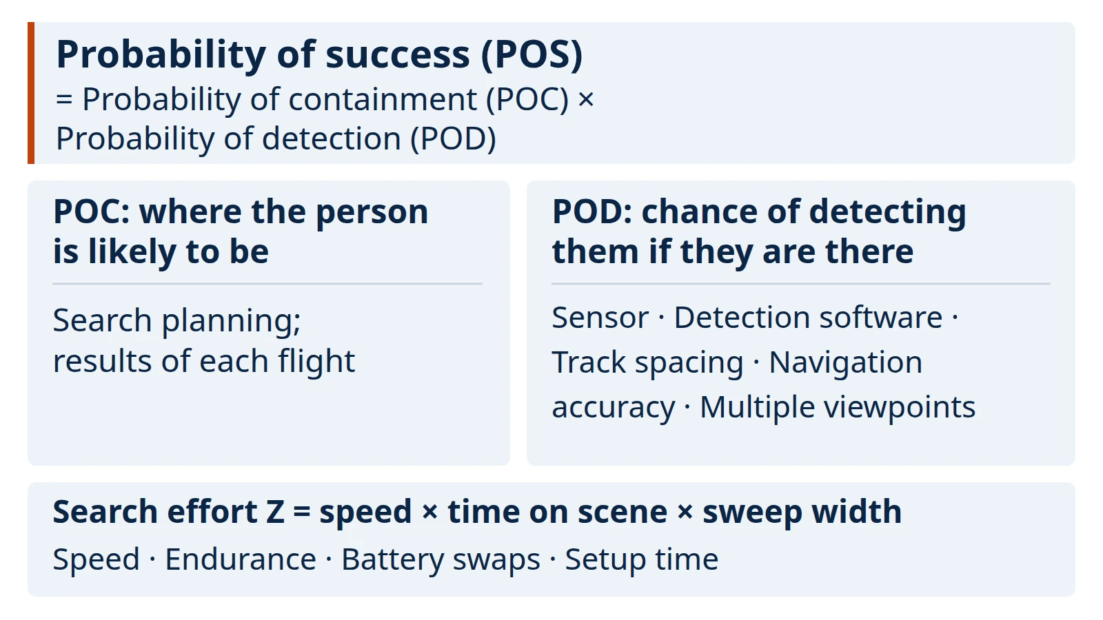
U.S. search doctrine defines the probability of success of a search in an area as the probability that the person is there, multiplied by the probability of detecting them if they are (POS = POC × POD). Our reading is that optimizing a drone search means raising POS within the time and effort available, not just carrying a better camera; POS itself is not a rate per hour. A drone can raise detection with sensors, image processing, flight-line spacing and navigation accuracy, and it adds search effort through speed and time on scene. Where leaves and branches hide the person, the effective sweep width of a visual or thermal search can shrink. The U.S. National Search and Rescue Supplement says dense foliage may hamper visual and electronic searches and require closer track spacing, and that searches over land almost always have to be repeated. How much closer, and how many passes, has to be checked for the sensor, the canopy and the conditions.
Key points:
- The useful question about any search and rescue drone is which term of POS = POC × POD it improves, and under what conditions.
- Canopy can narrow the effective sweep width of visual and thermal searches, so a plan built for open ground may leave gaps under trees.
- Research prototypes combine many thermal images taken from different positions to reduce occlusion by leaves and branches. That is different from a standard thermal camera seeing “through” trees.
- In the U.S., a Part 107 flight must stay within visual line of sight unless the FAA waives that rule; the FAA’s emergency process lists search and rescue among the operations it considers.
What does it mean to optimize a drone search?
In our reading, it means increasing the probability of success within the time and effort available; the NSS defines POS for an area, not per hour. The terms below come from the U.S. National Search and Rescue Supplement (NSS) to the international IAMSAR Manual; we use the glossary of the May 2000 edition. The right-hand column is our reading of where a drone fits.
| Term | NSS definition (paraphrased) | Where a drone can change it (our reading) |
|---|---|---|
| Probability of containment (POC) | Probability that the search object is inside a given area, sub-area or grid cell | Indirectly: results from each flight help planners re-weight where the person is likely to be |
| Probability of detection (POD) | Probability of detecting the object if it is in the area searched; depends on coverage factor, sensor, search conditions and how accurately the searcher follows its pattern | Sensor, image processing, track spacing, navigation accuracy |
| Probability of success (POS) | For each sub-area, POS = POC × POD | The outcome of both terms |
| Sweep width (W) | How effectively a particular sensor detects a particular object under specific environmental conditions | Sensor choice and altitude; shrinks under canopy |
| Track spacing (S) | Distance between adjacent parallel search tracks | Flight planning |
| Coverage factor (C) | Search effort divided by area searched (C = Z/A); for parallel sweeps, C = W/S | Tighter spacing raises coverage of an area |
| Search effort (Z) | Search speed × productive time on scene × sweep width (Z = V × T × W) | Speed, endurance, battery swaps, setup time |
Two consequences follow. First, detection and effort trade off: closer track spacing raises the coverage factor, but at the same speed and time on scene it covers less ground. Second, sweep width, and therefore POD, belongs to a sensor, a target and conditions together, not to the drone alone. A detection figure measured over open grass says little about the same aircraft over pine forest.
Why is forest canopy the hard case?
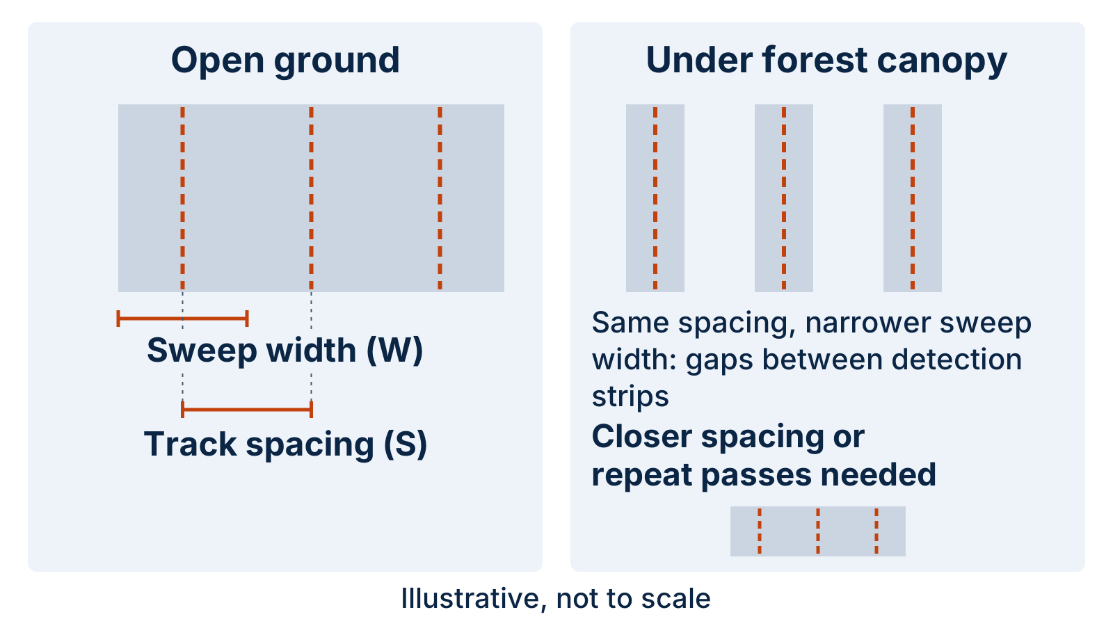
When leaves and branches hide the person from the sensor, a pass can detect less, and planners may need closer flight lines or repeated passes to make up for it. Three sources point the same way, though none gives a figure that transfers to every forest or sensor.
- Terrain guidance. The NSS says dense foliage “may hamper visual and electronic searches” and require more aircraft and ground teams and “closer search track spacing” (section 5.2.1).
- Repeat searches. Over land, “repeated searches of an area are almost always necessary to attain an acceptable cumulative probability of success” (NSS section 5.3.1).
- Drone-specific evidence. A 2023 scoping review of drones in wilderness search and rescue found support for using them to locate victims, assess risks, carry equipment and restore communications. The first limitation it listed was “objects obscuring victims,” followed by weather changes, uneven terrain, battery-limited flight time and susceptibility to environmental damage.
The NSS was written for crewed aircraft and ground teams. We apply it to drones because its definitions do not depend on the kind of platform: in sweep-width terms, where canopy shrinks W, the coverage factor at the same track spacing falls, and so does POD on each pass. Getting it back costs flight time, which is the scarce resource on a battery-powered aircraft.
Which levers improve a drone search, and what does each change?
Each improvement acts on a specific term, and each comes with a condition to check. A 2023 survey of the research literature groups the work into sensors for perceiving, locating and identifying targets; on-site monitoring and modelling; and operations such as task assignment, path planning and collision avoidance. The table maps the practical levers onto the search terms above.
| Lever | Term it acts on | What to check before counting on it |
|---|---|---|
| Sensor: visual, thermal or both | Sweep width (W) | Was it tried on people under similar canopy, at a similar time of day and in similar weather? |
| Detection software, including machine learning | POD, and the operator’s workload | Does it run live or after landing? How are false alarms handled, and who confirms a detection? |
| Combining many viewpoints (for example airborne optical sectioning) | Sweep width under occlusion | Research technique; it needs its own flight pattern and processing |
| Flight pattern and track spacing | Coverage factor (C), POD | Was spacing set for detection under these trees, or copied from open ground? |
| Navigation and positioning accuracy | POD (pattern flown as planned); location handed to ground teams | How far is a reported position from the person’s true position? |
| Speed, endurance, battery swaps, setup time | Search effort (Z) through speed and productive time | How much of each flight is spent actually searching? |
| Data link to the search team | Time from detection to action (not a POS term) | Range and bandwidth under trees; see our explainer on UAS data relay |
The “many viewpoints” row deserves a note, because it is one research approach aimed directly at canopy occlusion. Airborne optical sectioning (AOS), described in a series of papers by Schedl, Kurmi and Bimber, is a synthetic-aperture imaging technique: it registers many images from a moving drone to a common 3D frame to remove occlusion caused by leaves and branches. The same researchers reported a prototype that finds people fully autonomously in densely occluded forest, with thermal image processing, person classification and flight-path adjustment done on board in real time. Because it sends back only classification results that indicate a detection, they describe it as able to work over intermittent, low-bandwidth connections. A follow-up paper found that combining classifications from several AOS images suppressed false detections and boosted true ones, especially under occlusion. These are research prototypes evaluated by their developers, not products, and we do not repeat their detection rates here because they apply to their test conditions.
What did the 2021 FastFind challenge ask for?
FastFind, challenge 3.1 of NIST PSCR’s First Responder UAS Triple Challenge, targeted two of the levers above: image detection and navigation. According to the archived challenge page, contestants had to design, build and fly a complete UAS that helps a search and rescue team locate multiple missing persons in a thick forested area, improving image detection and navigation to “close the distance” more quickly. The competition’s home page described the focus as speeding up searches “where direct visual contact with a potential subject may be obscured.”
The challenge FAQ set the final-stage conditions: a search area no larger than 1,200 ft × 2,400 ft, trees about 30 ft tall and mostly pine, and a deploy-search-return cycle of an hour or less, without cellular networks. Those conditions match the trade-off described above: a fixed time budget over canopy that limits detection on each pass. The UAS Triple Challenge archive summarizes what the archived competition pages can confirm and links to NIST’s official results.
What limits a drone search in practice?
Rules, weather, terrain and batteries limit what a drone search can do, independent of how good the sensor is. This section summarizes the federal rules as published on 7 October 2026; it is not legal advice, so check the FAA’s current guidance for your operation.
- Visual line of sight. Under 14 CFR 107.31, the remote pilot in command, the person on the controls and any visual observer must be able to see the aircraft throughout the flight with vision unaided by any device other than corrective lenses, so they can know where it is, watch for other traffic and hazards, and make sure it does not endanger anyone. In forest, keeping the aircraft in sight can itself limit where a crew can stand and how far a search leg can run.
- Waivers. 14 CFR 107.205 lists the rules that can be waived, including visual line of sight (107.31) and operating several aircraft at once (107.35).
- Emergency authorization. The FAA’s emergency page (last updated June 16, 2026) says first responders responding to emergencies may be eligible for expedited approval through its Special Governmental Interest (SGI) process, and lists search and rescue among the operations considered. It notes that a beyond-visual-line-of-sight approval through this route will typically require a temporary flight restriction and longer processing than a standard emergency approval, which may be issued in minutes for operations within visual line of sight. If a request is denied, operators should not fly outside their existing authorization or Part 107.
- Environment and endurance. The 2023 scoping review lists weather changes, uneven terrain, battery-limited flight time and environmental damage among the limits on drones in wilderness search.
When does a better drone not shorten the search?
Because POS is a product, improving one term does little when another term is the bottleneck. The cases below are our reading of the search terms, not findings from a study.
- The person is probably elsewhere. If containment probability in the area being flown is low, a better sensor there adds little. Deciding where to search comes first.
- Spacing is set for open ground. A flight plan can “cover” a forest block on the map while detecting little under the trees, if track spacing ignores the smaller sweep width.
- Detections cannot be acted on. A possible sighting that the ground team cannot locate or confirm does not end the search. Position accuracy and a working link to the team matter as much as the detection.
- Little productive time. Setup, transit to the area and battery changes reduce time on scene, and with it search effort.
- No authorization for the area. If the crew cannot keep the aircraft in sight and has no waiver or emergency approval, the drone cannot fly the search as planned.
Questions to ask before trusting a detection claim
A detection claim is only useful for planning if you know the conditions behind it. Ask these questions of any vendor figure, research result or demonstration:
- What was the target: a person standing, sitting, lying down or partly covered?
- What was the canopy: tree species, density and season, compared with your area?
- What altitude, speed and track spacing were flown?
- What time of day, temperature and weather?
- Is the figure for one pass or for several passes combined?
- Who declared a detection: software, an operator watching live video, or a review after landing?
- How were false alarms counted?
- Was it a field trial with hidden people, a recorded dataset or a demonstration, and who ran it?
- How closely did the reported position match where the person actually was?
If a claim cannot answer most of these, treat it as a demonstration, not as a probability of detection you can plan a search around.
Method and sources
This page is compiled from public sources, not from our own flight tests. Definitions come from the U.S. National Search and Rescue Supplement, May 2000 edition, in a copy hosted by Civil Air Patrol; the newer edition on the U.S. Coast Guard’s website could not be retrieved when we checked, and the definitions used here are basic search-theory terms. Federal rules were read on eCFR and the FAA website on 7 October 2026. Research findings are taken from the papers’ published abstracts. Competition details come from archived copies of the challenge website. Nothing here is a safety, legal or compliance recommendation, or a judgment on any product.
Last updated: 7 October 2026.