Using the wrong path for a 0-foot grid can leave a Part 107 flight without an authorization on the job date. A 0-foot square on the UAS Facility Map is an informational altitude of zero, and that number is not an airspace authorization.
For a planned Part 107 flight in controlled airspace, file an airspace authorization before you fly above that zero. If the operation also needs a waiver, the LAANC page says to send the waiver and the authorization through FAADroneZone. If the operation is on an airport, the Part 107 authorizations page excludes that submission from LAANC further coordination. If there is no waiver, the operation is not on an airport, and the airport is LAANC-enabled, further coordination is the path that page describes for a 0-foot grid. If LAANC does not cover the airport, use FAADroneZone. Submitting the request is not an approval.
Key points:
- Read the altitude number in the square. Do not treat a color legend from one app as the rule on another map.
- Answer three questions in order: waiver, on-airport, then LAANC coverage. The route table below is that check.
- Further coordination is a review by the air traffic manager. It is the path for altitude above the grid, including a grid of 0 feet, with the on-airport exclusion.
- The FAADroneZone notice says processing has historically taken up to eight weeks. Without the approval, the flight is not authorized.
- Emergency requests, recreational flights, temporary flight restriction permission, and manufacturer unlocks are outside this checklist.
Independent explainer: this site is named after the domain once used by the First Responder UAS Triple Challenge and is not its organizer, NIST, or a university. Nothing here is an FAA approval or a legal opinion.
What does a 0-foot square tell you?
A 0-foot square tells you the altitude drawn for that cell is zero. The authorization, if the FAA issues one, is a separate document. You still file the request.
The UAS Facility Maps page, last updated 12 April 2023 and read on 12 October 2026, says the maps show the maximum altitudes around airports where the FAA may authorize Part 107 operations without additional safety analysis. The maps should inform requests for airspace authorizations and waivers in controlled airspace. The page’s note says the maps do not authorize operations at the depicted altitudes. They are for information only. Operators still apply, through LAANC or FAADroneZone, to fly in the controlled airspace that page lists: Class B, C, D, or surface area E.
The Part 107 airspace authorizations page, last updated 1 October 2026, calls those drawn values pre-approved altitudes. Near-real-time LAANC is for a flight at or below the map altitude. Further coordination is for a flight above that altitude, as long as the operation is under 400 feet. The notice at the top of the page includes 0-foot grids in that further-coordination option and excludes on-airport submissions. Any flight above the surface in a 0-foot square is above the map value, so the near-real-time steps do not supply that altitude.
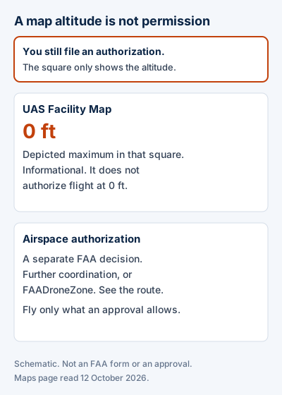
Schematic. The left side is the map altitude. The right side is the authorization, which exists only if the FAA issues one.
Read the number in the square, then check whether that airport is on the current LAANC facilities list. Those are separate facts. A LAANC airport can still contain 0-foot squares.
Two FAA pages give different airport counts. This checklist does not choose between them. The LAANC page, last updated 29 September 2026, says LAANC is available at 726 airports. The facilities page, last updated 4 August 2025, says LAANC is available at more than 500 LAANC-enabled facilities and more than 1,000 airports, and it links a list of covered airports. Look up the airport for this job on that list. The headline count is not the decision.
Which request path applies?
Use the first row whose conditions all match the job. Each row follows the FAA pages read on 12 October 2026. A submitted request still waits on an FAA decision.
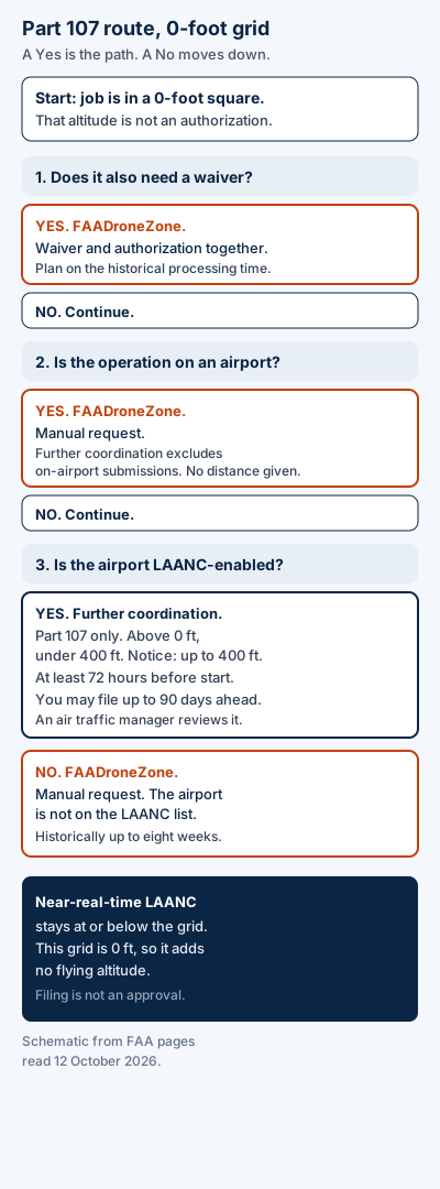
Schematic of the route check. Labels follow the FAA pages read on 12 October 2026. Filing a branch is not an approval.
| If this is true | File here |
|---|---|
| A waiver is also required | FAADroneZone, for the waiver and the authorization together. Ask for an altitude above 0 feet. One DroneZone sentence says at or below 400 feet, and the coordination sentence says below 400 feet. The notice says processing has historically taken up to eight weeks. Without the approval, the flight is not authorized. |
| No waiver, and the operation is on an airport | FAADroneZone. The authorizations page excludes on-airport submissions from further coordination, including 0-foot grids. Use the same altitude wording and the same historical processing time as the waiver row. The page gives no distance for “on-airport.” |
| No waiver, not on an airport, and the airport is LAANC-enabled | LAANC further coordination through an FAA-approved supplier. Altitude above 0 feet and under 400 feet. The notice also says up to 400 feet. File at least 72 hours before the start. You may file up to 90 days ahead. An air traffic manager reviews it. FAADroneZone can still take a manual request at a LAANC facility, and that request is not near-real time. |
| No waiver, not on an airport, and the airport is not LAANC-enabled | FAADroneZone. The authorizations page says it provides authorizations where LAANC is not enabled. The facilities page says to use the manual process there. Same altitude wording and historical eight-week note as the waiver row. |
| You would stay at or below the altitude drawn in the square | Near-real-time LAANC, at or below the map. In a 0-foot square that ceiling is 0 feet, so this row gives no positive altitude. The page says that approval is typically near-real time. |
Check the waiver before you treat LAANC as available. An on-airport operation drops out of the further-coordination sentence even when the airport is on the LAANC list. LAANC coverage is the third question.
The authorizations page says further coordination means the air traffic manager for that airspace reviews the request. If the request is denied, the page says the facility can provide guidance so you can adjust the operation and submit again. Adjusting and resubmitting is a new request. It is not permission to fly the profile that was denied. The same page says you will not be authorized to conduct the operation without the approval.
The LAANC page says LAANC provides airspace authorizations only. You still check NOTAMs, weather, and other airspace restrictions. Unless the authorization specifically requests it, that page says drone pilots do not need to notify the tower before they fly. If the authorization you receive tells you to call the tower, follow that authorization. The sentence is on the LAANC page. This article does not copy it onto a DroneZone approval you have not received.
The authorizations page does not define “on-airport” with a distance. Decide that from the location of the operation before you choose further coordination. This article does not add a radius.
What must the request contain?
Record the three route answers, then the fields the path you are using actually names. Leave a blank where the fact is still unknown. A blank records the gap. A guessed airport status hides it.

Illustration of a printed grid and a blank checklist on a desk. It is not an FAA authorization, a named flight, or a current app screen.
| Record this | What to write |
|---|---|
| Map altitude and the date you read it | 0 feet, the UAS Facility Map, and the calendar date. Do this before you open a portal. |
| LAANC coverage | Yes or no, which facilities list you opened, and the date. |
| On an airport | Yes or no, and what you used to decide. The authorizations page gives no distance. Yes sends you to FAADroneZone. |
| Waiver also required | Yes or no. Answer this before you choose LAANC. Yes sends the waiver and the authorization through FAADroneZone. |
| Location | The proposed operation in as much detail as you have. FAADroneZone calls this Proposed Location Of Operation. |
| Time window | Start, end, time of day, how often you will fly, and the local time zone. FAADroneZone names Start/End Date, Timeframe, Frequency, and Local Time Zone. Further coordination asks for the exact time. |
| Altitude AGL | The maximum you are requesting, above 0 feet and inside the ceiling for your row. FAADroneZone labels the field Proposed Maximum Flight Altitude About Ground Level (AGL). |
| Operation title | A clear, specific line about what you want to do. The page’s example is a photography shoot in MSP Class B airspace. FAADroneZone requires this. |
| Responsible party | The person responsible for the safety of the operation and for documenting the pilots and the make and model. The page says this person need not be the remote pilot and need not hold a remote pilot certificate. FAADroneZone requires this. |
| Reference | After you file: the FAADroneZone reference number, or the LAANC submission record. FAADroneZone status is under Manage Part 107 Waivers/Authorizations. |
For LAANC further coordination, when that is your row: select the exact time, altitude, and location. The authorizations page says a LAANC request may be submitted up to 90 days before the flight, and that a further-coordination request must be submitted at least 72 hours before the requested start. Use an FAA-approved UAS Service Supplier that offers Part 107 further coordination. The LAANC page lists those suppliers and says a name on the list is not an endorsement. This article does not open an app or describe its screens.
For FAADroneZone, when that is your row: log in, select “Create Part 107 Waiver/Authorization,” and in the pop-up titled “Part 107 Waiver/Authorization” choose the second option, Airspace Authorization, when the request is the authorization. When a waiver is also required, the LAANC page says you must apply for both through FAADroneZone. The clicks behind that combined case are not listed on the pages read for this article, so they are not invented here. Fill the required fields, review, and submit. The authorizations page says you then receive a reference number.
Submit a DroneZone request early enough for processing. The notice says review times vary and have historically taken up to eight weeks from the submission date because of volume and complexity. It says a late application may still be unprocessed when the operation starts, and you will not be authorized without the approval.
Further coordination on the LAANC page is available to Part 107 pilots only. That page says a Part 107 operator registers the drone and holds a Remote Pilot Certificate. The authorizations page limits its instructions to operations under Part 107.
When does this route not apply?
An emergency response uses a different FAA process. The emergency SGI request checklist is the page for a Special Governmental Interest request. This article stays with a planned Part 107 authorization.
Recreational flying under the statutory exception is outside this checklist. The LAANC page limits further coordination to Part 107 pilots.
Permission to operate inside a temporary flight restriction is a separate question. LAANC checks TFR data while it processes an authorization, and the LAANC page still tells pilots to check NOTAMs. This article does not describe how to get TFR permission.
A night flight in controlled airspace still needs the airspace authorization. The authorizations page says DroneZone authorizations cover day and night, and it points routine night flight without a waiver to the Operations Over People conditions: the Part 107 certificate, recurrent training, registration and marking, and anti-collision lighting visible for at least three statute miles. Those conditions do not replace the 0-foot-grid request.
A manufacturer geofence control is not an FAA airspace authorization. This article does not describe an unlock.
The FAA’s decision is the approval, the denial, or the silence while a request is still in process. The pages say where to send the request and what clocks they publish. They do not promise that the request will be granted.
Method and sources
This page is compiled from public FAA pages read on 12 October 2026. No authorization was submitted, and no LAANC application was opened.
The map’s role comes from the UAS Facility Maps page, last updated 12 April 2023. That page says the maps show maximum altitudes where the FAA may authorize Part 107 operations without additional safety analysis, that the maps are informational, and that they do not authorize operations at the depicted altitudes.
The 0-foot further-coordination sentence, the on-airport exclusion, the 72-hour minimum, the 90-day LAANC window, the eight-week historical DroneZone note, the DroneZone field list, and the manual DroneZone option at LAANC-enabled facilities come from the Part 107 Airspace Authorizations page, last updated 1 October 2026. A text extract saved on 11 October 2026 omitted Local Time Zone. The live page on 12 October 2026 includes Local Time Zone under Operation Parameters, and the last-updated line was still 1 October 2026.
The rule that a waiver and an airspace authorization both go through FAADroneZone, the statement that LAANC provides airspace authorizations only, the 726-airport sentence, the Part 107 limit on further coordination, and the supplier-list disclaimer come from the UAS Data Exchange (LAANC) page, last updated 29 September 2026.
The sentence “more than 500 LAANC-enabled facilities and more than 1,000 airports” comes from the Airports Participating in LAANC page, last updated 4 August 2025. Both counts stay in the article because both pages were live on 12 October 2026.
Guides written in 2021 that send every 0-foot grid only through FAADroneZone do not match the further-coordination sentence on the current authorizations page. Forum posts are not the procedure used here.
The photographs are illustrations of a printed grid and a blank checklist on a desk. They are not a documented flight, an issued authorization, or a current screen in a LAANC app.
Last updated: 12 October 2026.